
Tag: Anna Maria Island hurricane

Home sales and hurricanes

This is one of those times when I just want to put my head in the sand or at least lay on top of it and totally zone out. The weather is hot, hot, hot, the real estate market is cold, cold, cold and the threat of hurricanes is breathing fire down on us. Let’s start with the hurricanes.

Every hurricane prediction is in agreement that this will be an above-average season in the Atlantic Basin. The one I always look for is the Colorado State University forecast because I love that we’re getting our hurricane forecast from a landlocked mountain state. Nevertheless, their prediction is for 23 named storms, 11 hurricanes and five major hurricanes.

Before you put your head in the sand along with mine, remember that the Eastern Seaboard coastline is very long from as far north as Massachusetts to the southern tip of Florida and around into the Gulf of Mexico. My point is the hurricanes have a lot of area to choose from, but as they say, it only takes one and you have to be ready.

Anyone reading this lives either on the water or close enough to it that will require knowing your evacuation route, including emergency shelters and/or hotels or friends and relatives to evacuate to.

Get your three days’ worth of supplies for each family member where it is easily accessible. Nonperishable food, water, medications, first aid kit, flashlights, batteries, radio, cash, some clothing and important documents.

Secure your property, hopefully not the day before a storm is due, but how about right now? Window and door protections are at the top of the list.

Put away any outdoor projectiles, chairs, tables, toys, tree branches. If you have a garage, use it or move your vehicles to a more protected area. Get a backup power source, a generator, if you can arrange that. Turn off utilities, especially gas, and if you evacuate, leave your refrigerator and freezer free of raw meat or anything else that will go bad and damage your refrigerator if the power is off for several days.

Getting ready for hurricanes is one thing, getting ready for the real estate market is another thing. Let’s see what the May sales statistics show, released by the Realtor Association of Sarasota and Manatee:

Single-family homes closed 0.2% fewer properties than last May. The median sale price was $525,000, 1.9% lower than last year, and the average sale price was $709,406, up 3.4%. The median time to contract was 45 days compared to 32 days last year and there were 24.8% more new listings. The month’s supply of available inventory is 4.1 months compared to 2.7 months last year.

Condos closed 25.8% fewer properties compared to last year. The median sale price was $361,495, 5.5% lower, and the average sale price was $412,368, 32% lower than last year. The median time to contract was 56 days compared to 37 days last May, and new listings were down 5.3%. The month’s supply of available listings is 6.3 months compared to 3.4 months.

As you can see, the report of fewer sales and generally increased inventory is shifting the market to a potential buyer’s market. Condos are feeling the effects more than single-family, I believe partly because of the summer season, where potential buyers for winter condo retreats has declined. We’ll have to wait until the fall to see if this is the case; in the meantime, the condo market may continue to decline the further we get into hurricane season and warmer weather.

Meanwhile, be prepared for storms, stay alert and enjoy the warm Gulf waters.

Tracking Hurricane Idalia

Tuesday, Aug. 29, 5 p.m. UPDATE:

MANATEE COUNTY – Hurricane Idalia has been upgraded to a Category 2 storm with maximum sustained winds of 100 miles per hour. The storm is anticipated to continue to impact Anna Maria Island and the surrounding area this evening and overnight. County officials warn that the greatest risk the storm poses to this area is the chance for tornadoes to spawn from the hurricane and storm surge combined with a king tide expected to come in tomorrow morning at 11:30 a.m. Currently, NOAA shows that Anna Maria Island, Cortez and coastal areas of west Bradenton remain in the 4-7 foot peak surge warning zone.


Tuesday, Aug. 29, 3 p.m. UPDATE:

MANATEE COUNTY – Hurricane Idalia is classified as a Category 1 storm with sustained winds of 90 mph near its core. The storm is forecast to increase in strength to a Category 3 storm before making landfall. Currently, the hurricane is anticipated to make landfall mid-morning Aug. 30 near Cedar Key.

The outer bands of Idalia are bringing rain to the area. Anyone choosing to stay on the Island are asked to avoid driving through flooded areas and to shelter in place as the storm moves through the area.

A significant storm surge is expected with Hurricane Idalia. Due to a king tide expected Wednesday, Aug. 30 around 11:30 a.m., the highest storm surge is expected tomorrow morning. County officials advise residents and visitors to continue to shelter in place through tomorrow’s high tide. NOAA predicts 4-7 feet of storm surge for Anna Maria Island.

Hurricane Idalia storm surge forecast
Hurricane Idalia is expected to bring 4-7 feet of storm surge to Anna Maria Island. – Submitted

NOAA predicts sustained winds of 35 mph with wind gusts up to 50 mph for coastal Manatee County. County officials note that once winds reach a sustained 35 mph or roads become impassible due to flooding, first responders will not be able to respond to emergency calls.

There will be no trash pickups today or tomorrow. Recycling and yard waste pickups are canceled for the week.

Currently, there are no plans to cut water or other utilities to Anna Maria Island. Anna Maria Mayor Dan Murphy said that water will be shut off if Hurricane Idalia reaches a Category 3 designation or storm surge is expected at 7 feet or higher.

Holmes Beach Police Chief Bill Tokajer said that the drawbridges would not be raised at any time to prevent people from leaving the Island during the hurricane.

There will be no trash pickups today or tomorrow. Recycling and yard waste pickups are canceled for the week.

MANATEE COUNTY – Hurricane Idalia is on a collision course with the west coast of Florida. The Sun is committed to giving you the latest updates as the storm moves closer to Anna Maria Island.

County officials issued a press release at 9:37 a.m. today including newly announced closures. Manatee County Area Transit buses will stop operations at 2 p.m. today or earlier if weather conditions call for an earlier suspension of service. Transportation services will remain suspended until it is safe to restart them.

Level A residents and visitors, including everyone living in mobile homes, Anna Maria Island, Perico Island, Flamingo Cay, waterfront areas of west Bradenton, and Cortez, are under a mandatory evacuation with Level B residents and visitors under a voluntary evacuation notice. All residents who evacuate are reminded to take their re-entry tag issued from their city in order to gain access to the Island after the storm passes. Anyone who chooses to shelter in place on the Island is advised that all first responders and emergency personnel will be grounded once winds reach a sustained 45 mph.

County officials warn that while wind and rain are expected as Hurricane Idalia moves closer to the west coast, the major cause for concern is storm surge, which could happen near an already expected king tide on Wednesday. As of a 4 a.m. update, NOAA was projecting a storm surge near Anna Maria Island of 4-7 feet.

Hurricane Idalia surge
The current peak surge forecast for Hurricane Idalia as of 4 a.m. on Aug. 29. – Submitted

Sandbagging stations are open at Bayfront Park in Anna Maria, City Field in Holmes Beach, Coquina Beach in Bradenton Beach and GT Bray on 59th Street in Bradenton.

All Manatee County libraries are closed until Thursday, including book drops.

All Manatee County schools are closed until Thursday morning at this time pending assessments after the storm passes.

Emergency shelters are open for those who need them. Shelters should be considered a last resort and anyone who can is asked to shelter in place with friends or family outside of the evacuation zone. A list of open shelters can be found online. If going to a shelter, take bedding, food, water, medications and other supplies to last for at least three days. Note that not all shelters are pet-friendly. If you’re taking a pet, make sure the pet has a crate, food, water, leash, litter box (if needed) and any other supplies necessary for a three-day stay. All pets must be accompanied by their owners and owners must furnish proof of recent vaccinations.

Manatee County officials are scheduled to give a 3 p.m. update from the Emergency Operations Center which can be viewed live on YouTube and Facebook.

While Idalia is not currently forecast to make a direct impact on Anna Maria Island, county officials warn residents and visitors to keep an eye on the weather and watch as models of the path of the storm are updated throughout the day. Keep checking back to this post for the most up-to-date information from The Sun.

Hurricane Expo stresses preparedness

Hurricane Expo stresses preparedness

PALMETTO – Even though Anna Maria Island and most of Manatee County dodged the worst of Hurricane Ian last year, there were still plenty of lessons learned, and the community was reminded of how much of a threat a major hurricane is to the area, especially those living on the barrier islands like AMI.
Even with the storm turning in its final hours of approach to the Island, many still went close to a week without power and there was significant wind damage. To help the community be better prepared for future hurricanes, Manatee County hosted the Third Annual Hurricane Preparedness Expo on May 18 at the Bradenton Area Convention Center in Palmetto.

The expo featured more than 50 booths with valuable information about how to survive a storm. There was plenty to take away from the event, but the theme echoed by most experts was to be prepared, take watches and warnings seriously, and when told to evacuate, to do so as quickly as possible.

There were rescue vehicles from multiple agencies that do search and rescue in the county, law enforcement was on hand to answer questions and dozens of vendors were on hand to answer questions about everything from stormproof doors and windows to how to take care of pets during a disaster.

“We begin to mobilize long before a major storm hits the area,” said Gary Weinstein, of the Red Cross Manatee County. “Getting food, water, medical supplies and other anticipated post-disaster necessities is vital to help those in need after the storm.”

Carolyn Nielson of the Manatee County Salvation Army echoed the Red Cross regarding being prepared and being ready to step in when needed. The Red Cross had its relief truck on hand at the event.

“We come out and not only get food and water to people in the community that need us, but we also serve first responders and those helping in the effort after a storm who work long hours to serve others,” Nielson said.

Sun Coast Blood Center was on hand as well, and stressed the need to give blood before a disaster hits.

“It takes a bit of time for blood donated to be processed, so waiting until after a disaster isn’t the best option,” Sun Coast Blood Center’s Whitlie Turner said. “Now, before hurricane season, is when we really encourage people to come out and give blood.”

Castles in the Sand

The Ian effect

My friend who lived near me in Cortez calls it the “Cortez Effect.” The legend is that the Native Americans who inhabited the Cortez peninsula put a curse on the storms so they wouldn’t come ashore in their homeland, keeping their burial grounds protected. She and I lived through many storms and almost-storms during the more than 20 years we both lived in Cortez, and we always seemed to dodge the bullet. Well, this time we dodged the biggest bullet of all, and we should all be grateful.

The other question is now that we’re all safe and comfortable, we can start to think about the economic impact of one of the most expensive storms to ever hit Florida. The economists are already addressing this and indicate that Ian will likely negatively affect the economic growth of the country through this year. Typically, when the rebuilding and recovery starts, the economic benefits will be spread out over the next few years. Unfortunately, because of the shortage of construction workers and materials, Florida’s economic comeback could take some time.

The economists’ consensus is that natural disasters have a relatively modest economic impact, especially short term once businesses start to rebuild and reopen. As far as real estate values, Florida’s worst hit regions were also the fastest growing in the state and indeed the country and won’t be permanently damaged. The unemployment rate in both Tampa and Fort Myers were 2.7% in August, lower than the national rate. Both of these regions have seen a rapid influx of new residents during the pandemic. In addition, Florida’s economic growth has outpaced the country’s every quarter since the beginning of 2021.

Long-term Florida residents are used to major storms, and they and the state have prepared for them. In May the state set aside $2 billion to help insurance companies handle claims. That said, you can be sure the fallout for insurance companies will be big. Underfunded companies may go out of business, homeowner’s policies will be dropped, and rates will go up. This is just what we don’t need at a time when attracting new insurance companies to the state has been a challenge. As always, my recommendation is if you have a good homeowner’s policy and you don’t get dropped, live with the possible premium increase and be happy, especially for the next few years.

Finally, the U.S. Census Bureau and the Bureau of Labor Statistics say that the earnings of people affected by hurricanes outpaced other workers who weren’t affected within three years of the storm. As previously stated, this is all because of workers needed to help rebuild and get the economy rolling again.

There will be pain at the beginning a lot of it – just look at those awful pictures from our neighbors not too far south and try and imagine yourself in that situation. Help is needed, mostly donations – especially to the Red Cross – but anything you and your family can do to ease their pain even a little would certainly be appreciated.

I don’t hold a lot of belief in legends, and, as another friend pointed out, maybe the indigenous Native Americans actually studied weather patterns over a period of decades and never really cast spells. But legend or not, we in Cortez and on Anna Maria Island have been extraordinarily lucky, and we shouldn’t forget that eventually, luck runs out. Let’s remember that in 1921 the Cortez fishing village was all but destroyed by a major hurricane.

This is October, the month of Halloween, so let’s hope the Native Americans are still casting their magic spells if indeed that’s the reason. I for one want to believe whatever keeps those storms away, magic spells or the study of weather science. I’ll accept either one as long as it works.

Anna Maria Island dodges Hurricane Ian’s bullets

Anna Maria Island dodges Hurricane Ian’s bullets

ANNA MARIA ISLAND – Hurricane Ian inflicted significant damage on some mobile homes in Bradenton Beach, but Anna Maria Island as a whole survived the hurricane without the widespread devastation many feared.

On Monday, Sept. 26, Manatee County ordered a mandatory evacuation of all three Island cities, to be effective the following evening. A drive around the Island just before sundown on Tuesday evening revealed many boarded-up businesses and homes and a mostly deserted and evacuated Island.

Residents, business owners and others were allowed to return to the Island at 10 a.m. on Thursday morning,

Manatee County restored water and sewer service to the Island on Friday morning, but as of late Saturday afternoon, most of the Island remained without electrical power.

In Bradenton Beach, power was restored to the Bridge Street area and the residential area south of Bridge Street on Friday night. The power in those areas went out again Saturday morning and was then restored to some locations.

Bradenton Beach Police Chief John Cosby said the power outage that occurred after the power was initially restored was due to a switching device catching fire and needing to be replaced.

With the power partially restored again, the Drift In bar in Bradenton Beach was the first Bridge Street establishment to reopen late Saturday morning.

“With everything that’s happened in the past few years, including COVID, my team needs to work,” Drift In Manager Doreen Flynn said shortly after the reopening. “I feel sick thinking of all those people who were not as lucky as us.”

As of late Saturday afternoon, several other Bridge Street businesses remained without power or closed for other reasons.

Assistant General Manager Shannon Dunnan said the Bridge Tender Inn & Dockside Bar had power and hoped to reopen early Sunday afternoon.

Island Time General Manager Michael Davis said they did not yet have power as of Saturday afternoon and hoped to have a soft reopening on Monday and be fully reopened on Tuesday.

Bridge Street Bazaar owner Jake Spooner said his business remained closed on Saturday afternoon because there was no power. The Daiquiri Deck also remained closed on Saturday.

Bradenton Beach

On Thursday morning, Bradenton Beach Police Chief John Cosby provided The Sun with a damage assessment.

“We started operations at 3 o’clock this morning and we had the team fully operational by 5 a.m. We did good. The only real damage we had to our city facilities was the police department roof was leaking. The worst damage is in the two trailer parks where some roofs and carports were blown off. We also had some damage to a condo on the 600 block,” Cosby said.

Unlike past storms, none of the live-aboard boats south of the Bridge Street Pier broke free and struck or damaged the pier or floating dock.

“The pier and floating dock did good,” Cosby said. “We’ve got two boats missing, one boat down and one boat – we don’t where it came from – leaning against the bridge. There’s no damage to the bridge and FDOT’s been notified.”

“The cell tower is damaged. It got hit by some flying debris that left some good-sized dents in it. I don’t know if it’s operational or not. Our cell service is terrible right now, so it may have been disrupted,” Cosby said.

Cosby said there was a lot of tree and landscaping debris to clean up, but the main roads had already been cleared by the city’s public works department.

“We had no major power lines down, so that should make it quicker to restore power. Right now, we do not have any power, water or sewer; and we have no idea when those are coming back,” he said Thursday morning.

Cosby noted the county and FPL were dealing with significantly worse damage in eastern Manatee County.

“The east side of the county got destroyed. When the storm went over that way, it was a Cat 2/Cat 3. They were rescuing people off roofs this morning,” he said. “The county’s got a lot to take care of. Hopefully, we can get the utilities up as fast as we can, but I think it’s going to be a while,” he said.

When asked about the city being reopened to those who wished to return, Cosby said, “We’re allowing them to come back. If they want to stay, they can, but there’s no power, no water and no sewer.”

Holmes Beach

When contacted later that morning, Holmes Beach Police Chief Bill Tokajer said, “We had minimal damage – some trees and limbs. Power’s out. We have no water yet. We have no Spectrum connectivity.”

He also said, “Full access to Holmes Beach through Manatee Avenue was opened at 10 o’clock this morning. Once the Island was deemed an evacuation zone, we limited the number of people that returned to public safety personnel, but we never raise the bridges and we never stop people from leaving the Island.”

Tokajer reflected on what could have been had Hurricane Ian not taken an unexpected turn to the south, including catastrophic damage to the Fort Myers/Sanibel Island area.

“We were truly blessed. The damage and devastation we’re seeing to the south is what we were expecting as a direct hit to our area. It’s truly daunting to see the devastation that happened down there – and to see what a true storm surge looks like in real life, instead of just projections,” he said.

On Friday, traffic coming into Holmes Beach on Manatee Avenue was being detoured south on East Bay Drive because a fallen power pole was leaning on the metal pole that holds the traffic signal.

Anna Maria

When visited in his generator-powered city hall office early that afternoon, Anna Maria Mayor Dan Murphy said, “We did good. We didn’t take a direct hit. If we had, it would have been devastating for our city. We had a lot of trees down and several wires down, but we have most of that cleared. The city’s without power and water. I have no idea when utilities are being restored. People can come back but it’s not real comfortable without water and power.”

The exterior skin of the Anna Maria cell tower had a large tear in it, but Murphy said he wasn’t aware of any significant structural damage that occurred within the city, other than one home having its front door blown off.

“The only significant problem I see is turned over port-a-potties at construction sites. Several contractors picked theirs up, but one contractor didn’t bother to tie them down or pick them up. That’s a problem and a health hazard, and that’s something we put in our construction checklist,” Murphy said.

In 2017, the damage inflicted by Hurricane Irma led to the City Pier being closed and later replaced. When asked how the new pier fared during its first hurricane, Murphy said, “Our new pier held up fine. There’s no structural damage at all. It was built right. I was concerned – like a father whose daughter goes on her first date.”
Anna Maria residents JoAnn and Anthony Manali chose not to evacuate and rode the storm out at their home and business, Captain Anthony’s Stone Crab Store.
“I was scared and I’ll never do it again. It was worse than I could have ever imagined,” JoAnn Manali said of that experience.

On Friday morning, Murphy was advised that it could take another four or five days to restore power in Anna Maria.

On Saturday, Murphy said the storm debris removal efforts were already underway and storm recovery updates and information were available at the city website.

Hurricane Ian, a day at a time

Hurricane Ian, a day at a time

Hurricane Ian caused a burst of activity and emotion on and around Anna Maria Island last week.

On Tuesday, it was projected to make landfall here, but by that afternoon, new projections had it veering slightly south, where it made landfall the next day at Cayo Costa.

Local residents were left feeling both relief and distress over the misfortune of their southwest Florida neighbors, and more than a little apprehension about the next storm.

Here’s what happened while thousands prepared to either face or run from the disaster.


Sept. 25 – City leaders in Anna Maria declare a local state of emergency in preparation for Hurricane Ian.

Sept. 26 – City leaders in Holmes Beach and Bradenton Beach declare a local state of emergency.

Sept. 26, noon – A mandatory evacuation of zone A, including Anna Maria Island, Cortez and sections of unincorporated Manatee County is issued, effective at 8 a.m. on Sept. 27.

Sept. 26, 2 p.m. – Manatee County schools, libraries and The Center of Anna Maria Island announce closures effective at the end of the day. Trash and yard waste collection cease.

Sept. 26, 5 p.m. – The latest Hurricane Ian update from the National Hurricane Center shows the storm taking a turn for Tampa Bay.

Sept. 27, 8 a.m. – Evacuation of zone A goes into effect. Manatee County shelters open at local schools. The projected track of Hurricane Ian takes a turn for a direct hit to Anna Maria Island.

Sept. 27, 11 a.m. – Manatee County leaders issue mandatory evacuation orders for zone A and B with a voluntary evacuation for zone C.

Sept. 27, 5 p.m. – Water and sewer services are turned off to Anna Maria Island. Traffic to the Island is limited with Manatee Avenue and Cortez Road traffic limited to eastbound only. Anna Maria Island is placed under a flash flood warning. The Island, Cortez, Perico Island, Flamingo Cay and parts of coastal unincorporated Manatee County are placed under a storm surge warning. Manatee County is under a hurricane warning. Hurricane Ian is expected to come onshore near Port Charlotte and hit Manatee County around 2 a.m. Sept. 29 as a Category 1 storm.

Sept. 28, 10 a.m. – Hurricane Ian is upgraded to a Category 4 storm. Manatee County is already experiencing high winds and rain from the hurricane.

Sept. 28, 3:10 p.m. – Hurricane Ian makes landfall as a Category 4 storm with sustained winds of 155 mph at Cayo Costa, near Captiva Island and Sanibel. Manatee County is under a flash flood warning and storm surge warning.

Sept. 28, 5 p.m. – Manatee County lift stations have lost power and water treatment facilities are near capacity. Three potable water main breaks have been identified and two have been fixed. Residents are asked to limit water usage.

Sept. 29, 10 a.m. – Manatee County evacuation orders have been lifted and shelters are closing. Utility crews are assessing system damage. Access to Flamingo Cay and Perico Island is reopened.

Sept. 29, 10:20 a.m. – Holmes Beach police announce that Anna Maria Island is reopened to residents.

Sept. 30, 5 p.m. – Water and sewer utilities are returned to Anna Maria Island. The Island is under a 48-hour boil water notice. Some electrical utilities have been restored, then lost again.

Oct. 1, 5 p.m. – Electricity has been returned at 90% to Anna Maria Island, Perico Island, Flamingo Cay and Cortez. The Center of Anna Maria Island is expected to reopen on Oct. 3 along with county beaches, parks, libraries and other amenities. The weather is sunny and cool, with no storm in sight.

Anna Maria Island prepares for Hurricane Ian

SEPT. 29, 10:20 A.M. UPDATE: Holmes Beach police have announced that Anna Maria Island is back open for residents.

SEPT. 29, 10 A.M. UPDATE: Manatee County evacuation orders have been lifted and shelters are closing this morning. Utility crews are assessing system damage. Anna Maria Island is still closed to residents with drivers being turned around at the base of the Anna Maria and Cortez bridges while first responders and work crews assess the state of the Island. Residents can access Flamingo Cay and Perico Island on Manatee Avenue. Anyone out driving is asked to be cautious of downed or sagging powerlines, storm debris and standing water.

SEPT. 28, 5 P.M. UPDATE: Manatee County officials have asked that residents who still have water limit what goes down their drains. With lift stations losing power and water treatment facilities at capacity, along with potable water breaks reported, residents are asked to limit toilet flushing, showering, doing dishes and doing laundry.

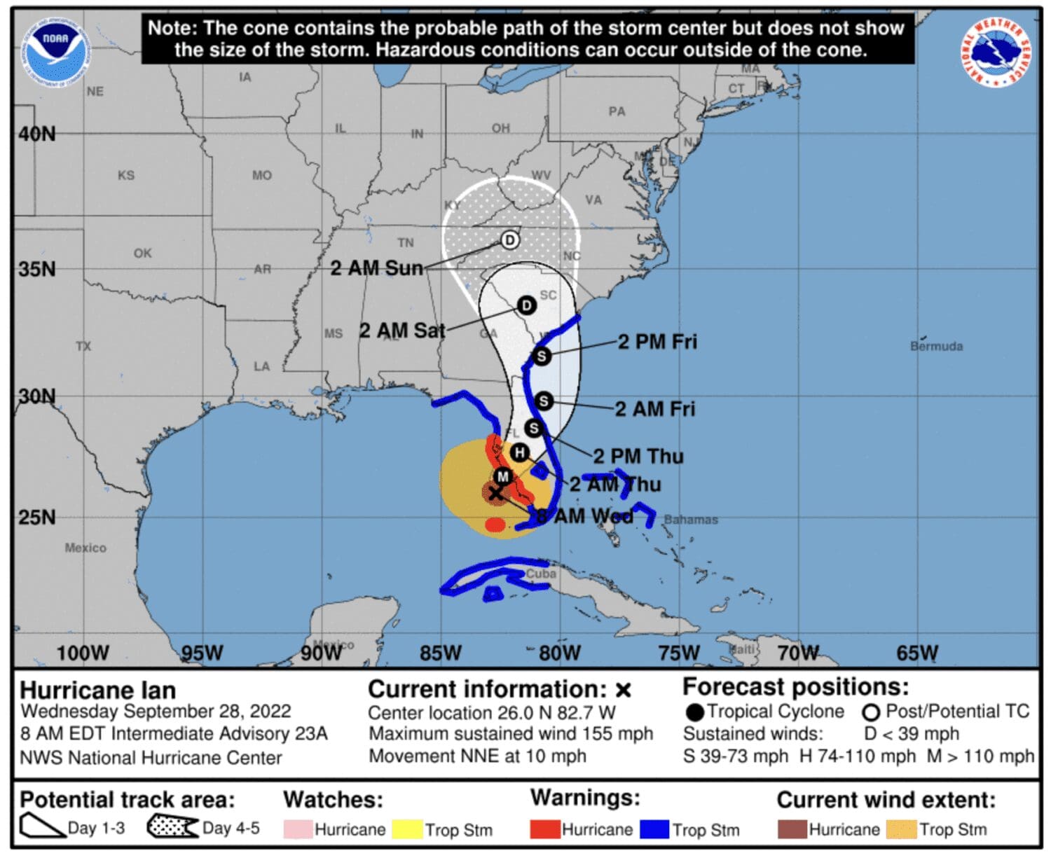
Hurricane Ian made landfall around 3:10 p.m. near the Captiva Islands and Sanibel as a Category 4 storm. Manatee County is under a flash flood warning until 7 p.m., an extreme wind warning until 6 p.m. and an ongoing storm surge warning for coastal low-lying areas.

SEPT. 28, 10 A.M. UPDATE: Power outages are expected to occur in our area over the next several hours. Hurricane Ian has been upgraded to a Category 4 storm and our area is already experiencing high winds and rain. The storm is expected to make landfall to our south late morning or early afternoon today. The Sun will post updates here and on our Facebook page as we’re able due to internet and power outages. Everyone, stay inside, stay safe and we’ll see you on the other side.

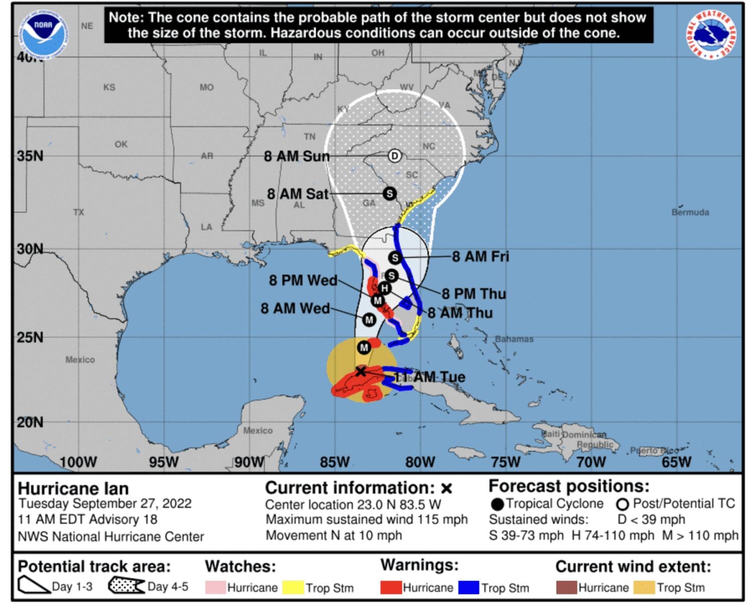
SEPT. 27, 5 P.M. UPDATE: The National Hurricane Center’s latest update is showing that Hurricane Ian is expected to come onshore near Port Charlotte early Wednesday afternoon as a possible major hurricane. If the storm follows the current track, it’s anticipated that it will approach the Manatee County area early Thursday, Sept. 29 around 2 a.m., potentially as a Category 1 storm.

The peak storm surge warning for Anna Maria Island and Cortez has been lowered to an estimated maximum of 4-6 feet. The estimated storm surge for Anna Maria Island and Cortez has been reduced to 1-3 feet above ground level.

Manatee County officials announced that water and sewage lift stations on Anna Maria Island will be turned off at 6 p.m. today, Sept. 27. Water and sewage services will not be restored until after the storm threat has passed. County Administrator Dr. Scott Hopes warned residents that sewage lift stations, needed to operate toilets, will not work if electricity is out.

Westbound traffic on Manatee Avenue and Cortez Road to Anna Maria Island from the mainland became restricted at 4 p.m. today and will be closed by 8 p.m. this evening. Traffic lanes will not reopen to the Island until local law enforcement and first responders determine that it’s safe for residents to return.

SEPT. 27, 11 A.M. UPDATE: Manatee County has issued mandatory evacuation notices for zones A and B with a voluntary evacuation notice in place for zone C. If you’re unsure of your evacuation level, visit the county website for more information.

County officials advise that all residents should be sheltered where they plan to ride out the storm as of 8 p.m. tonight when some of the first effects of Hurricane Ian are expected to be felt in the area. All county shelters are now open. A list of shelters in the area can be found here.

All pet owners are advised to bring their pets inside for the duration of the storm. Manatee County Animal Services will close today and not reopen until safe to do so after Hurricane Ian has passed.

All of Manatee County, including Anna Maria Island, is under a flash flood warning beginning Sept. 28 and continuing through Friday, Sept. 30.

Anna Maria Island, Cortez, Perico Island, Flamingo Cay and parts of coastal unincorporated Manatee County are under a storm surge warning. While most areas can expect storm surge of over 3 feet, some areas of the Island, including in Anna Maria and Holmes Beach, can expect storm surge of over 6 feet during high tide. The National Hurricane Center’s storm surge flood map is consistently being updated online as the storm’s track is updated. Peak storm surge along coastal Manatee County is expected to be between 5-9 feet.

City commission regular and work session meetings in Holmes Beach scheduled for today at 5 p.m. have been canceled. Commissioners will go forward with a final budget hearing and emergency special meeting at 5:01 p.m. today via Zoom. The public is invited to participate online or by telephone.

SEPT. 26, 5 P.M. UPDATE: Manatee County is now under a hurricane warning from the National Weather Service. Anna Maria Island and surrounding low-lying areas in Manatee County also are under a storm surge warning. The storm surge warning is in effect until Friday, Sept. 30 and states that the Island could see waters rise 3 feet or more above sea level. Peak storm surges could exceed 10 feet in some areas if Hurricane Ian arrives in the area at high tide.

SEPT. 26, 2 P.M. UPDATE: Closures have been announced for Manatee County.

Manatee County schools are closed for students and staff beginning tomorrow. Schools will be closed until the threat of Hurricane Ian has passed.

The Center of Anna Maria Island and all Manatee County Libraries will close at end of business today, reopening after the storm threat has passed. The Anna Maria City Pier will close at noon Sept. 27 and remain closed until further notice.

There will be no trash, recycling or yard waste collection on Wednesday until after the storm threat passes. Due to evacuation notices for Anna Maria Island, collection services may end early on Tuesday.

All Manatee County facilities and buildings will close to the public at close of business today with the exception of the county administration building which is scheduled to close to the public after a scheduled county commission meeting the morning of Sept. 27.

Shelters in Manatee County will open tomorrow morning at 8 a.m. Manatee County officials ask that no one go to a shelter prior to the 8 a.m. opening on Sept. 27. A list of shelters is available online. Everyone going to a shelter needs to bring their own cot or sleeping bag and personal items.

Manatee County Sheriff Rick Wells has announced that emergency services will be very limited once winds hit a sustained 45 mph. He advises that officers will do their best to respond but may not be able to get to all areas of the county while the effects of Hurricane Ian are being felt in the area. Emergency services in Manatee County, including EMS, fire response and law enforcement will all be limited during the storm event.

Storm surges, high winds and heavy rain are expected to begin as early as 2 a.m. on Tuesday, Sept. 27 and continue through early morning Friday, Sept. 30. A mandatory evacuation is effective beginning at 8 a.m. Sept. 27 for zone A, which includes Anna Maria Island, and a voluntary evacuation for zone B. Manatee County Administrator Scott Hopes recommends that everyone be where they intend to ride out Hurricane Ian by tomorrow night at 8 p.m. Hurricane Ian is predicted to have a high probability of spinning off tornadoes.

Anna Maria Island will be closed down at sundown tomorrow afternoon, Sept. 27. Water utility services will be shut off one hour after sundown tomorrow afternoon and Hopes said service will not be restored until it can be safely determined that the system has not sustained any significant damage.

SEPT. 26, 12:10 A.M. UPDATE: A mandatory evacuation of zone A, including Anna Maria Island, Perico Island, Cortez and parts of unincorporated Manatee County, has been issued by Manatee County effective at 8 a.m. on Tuesday, Sept. 27. Evacuation of zone B is advised but not mandatory.

ANNA MARIA ISLAND – Residents and city leaders in the three Island cities are preparing for potential impacts this week from Hurricane Ian as the storm is projected to pass by to the west in the Gulf of Mexico as a major hurricane.

As of the National Weather Service’s Sept. 26 11 a.m. briefing, the Tampa Bay area, including Manatee County, is under a hurricane watch with the storm expected to rapidly intensify. Hurricane Ian is currently expected to pass by the area as a category 2 or 3 storm. Early forecasts predict 7-10 inches of rain in our area and storm surges of 5-8 feet. Impacts from Hurricane Ian are expected to begin in Manatee County as early as Wednesday evening and continue through Thursday, Sept. 29.

Holmes Beach Police Chief Bill Tokajer and Mayor Judy Titsworth said the Island is anticipated to be under a mandatory evacuation by 8 a.m. on Tuesday, Sept. 27. While residents will not be forced to leave, it is important to note that emergency services, including police, fire response and EMS, will not be available during a storm. West Manatee Fire Rescue personnel will be required to leave the Island once sustained winds exceed 45 mph.

Anna Maria

A state of emergency has been declared by city officials. Residents are advised to prepare for impending impacts from Hurricane Ian. A sandbagging station has been set up for residents at Bayfront Park, however, supplies of sandbags and sand are limited. Reentry tags are available for residents at city hall with proof of residency.

Bradenton Beach

City officials declared a state of emergency during an 11 a.m. meeting this morning. Manatee County staff have delivered pre-filled sandbags to Coquina Beach for residents over the weekend but those supplies have quickly been depleted. Reentry tags for residents are available at the Bradenton Beach Police Department with proof of residency.

Holmes Beach

Titsworth declared a local state of emergency for the city early Monday morning. Sand and sandbags are available as supplies are replenished at the Manatee Beach and by the pickleball courts at city field. Reentry tags are available for residents with one tag being issued per residence at the Holmes Beach Police Department.

The Holmes Beach Code Compliance Special Magistrate hearing scheduled for 10 a.m. Sept. 27 has been canceled. The city commission meeting and work session scheduled to follow the budget hearing at 5:01 p.m. on Sept. 27 have been canceled. Titsworth said she anticipates that the budget hearing also will be canceled due to the mandatory evacuation.

The Sun will continue to update this post as more information becomes available.

Hurricane season’s second half could be unusually active

Hurricane season’s second half could be unusually active

CORTEZ – Halfway through a quiet hurricane season, it’s too soon to relax, as experts are still predicting above-normal 2022 Atlantic hurricane activity.

Atmospheric and oceanic conditions still favor an above-normal 2022 Atlantic hurricane season, according to the National Oceanic and Atmospheric Administration’s (NOAA) annual mid-season update, issued this month by the Climate Prediction Center, a division of the National Weather Service. The hurricane season runs from June 1 to Nov. 30.

A timely rotating exhibit currently at the Florida Maritime Museum (FMM) titled “Caught in the Storm: 100 Years of Florida Hurricanes” revisits some of the worst coastal storms to impact the state – several of which hit locally.

An unnamed hurricane in October 1921 covered the Gulf coast in water from Fort Myers to Tarpon Springs, causing devastation to the Cortez waterfront.

“In Cortez, fishermen watched their industry be nearly swept away. The storm’s waves left behind mounds of debris tangled in nets where fish camps and docks once stood,” according to the FMM exhibit. “Left without markets to sell to, the fishermen created their own, some of which still remain on Cortez’s waterfront.”

The Cortez Public School, which still stands at 119th Street West and Cortez Road and is now the Florida Maritime Museum, is the highest point in Cortez and was used as a shelter during that storm, which had an 11-foot storm surge.

In October 1944, a major unnamed hurricane known unofficially as the Cuba-Florida Hurricane “struck the Bradenton/Sarasota area causing trees to fall across the road taking out power lines and disrupting all communications between the Keys and the mainland.”

Hurricane Alma in June 1966 was another storm highlighted in the exhibit, with the following recollection from Cortez resident August Antilla, “…by nightfall Ellen and I had purchased $12 worth of cheeses, cold cuts and candy, and we were looking forward to our cozy hurricane party, just the two of us. The radio was blaring continually… ‘Evacuate, Anna Maria Island. The tide will be 7 to 11 feet above normal.’ ”

The largest hurricane evacuation in U.S. history happened just five years ago in September, 2017 with 6.5 million people fleeing their homes in anticipation of Hurricane Irma. Hurricane track predictions included a “cone of uncertainty” with Irma; that cone covered the entire Florida peninsula. In an abundance of caution, many counties issued mandatory evacuation orders.

So far this year, the season has seen three named storms – Alex, Bonnie and Colin – and no hurricanes in the Atlantic. An average hurricane season produces 14 named storms, of which seven become hurricanes, including three major hurricanes.

NOAA forecasters have slightly decreased the likelihood of an above-normal Atlantic hurricane season to 60% from the May prediction of 65%, but more than 60% of hurricanes that make landfall do so after the peak of the season in September.

“We’re just getting into the peak months of August through October for hurricane development, and we anticipate that more storms are on the way,” NOAA Administrator Rick Spinrad said.

“I urge everyone to remain vigilant as we enter the peak months of hurricane season,” U.S. Secretary of Commerce Gina Raimondo said.

For more information, check out The Sun’s Hurricane Guide.

Busy hurricane season predicted

The forecasters at Colorado State University’s Tropical Weather and Climate Research department predict a busier than average 2022 hurricane season for the Atlantic basin, including the Gulf of Mexico. The season could spawn 19 named storms with nine of those turning into hurricanes and four becoming major hurricanes.

To be named, a storm must have wind speeds of 39 mph or higher with a circular rotational pattern. Hurricanes are named storms with winds of 74 mph or higher while a major hurricane is considered one that ranks as a category 3, 4 or 5 storm with wind speeds beginning at 111 mph.

Forecasters anticipate that with increased water surface temperatures in the Caribbean and subtropical Atlantic seas, there is an above-average chance of major hurricanes making landfall along the southern U.S. and in the Caribbean.

The forecasters at the National Oceanic and Atmospheric Administration’s Climate Prediction Center are predicting yet another busier-than-average Atlantic hurricane season, with the possibility of 13-20 named storms, six to 10 hurricanes and three to five major hurricanes classified as Category 3, 4 or 5.

To be named, a storm must have wind speeds of 39 mph or higher with a circular rotational pattern. Hurricanes are named storms with winds of 74 mph or higher, while a major hurricane is considered one that ranks as a Category 3, 4 or 5 storm with wind speeds of 111 mph or higher.

NOAA forecasters also predict a 60% chance of an above-normal hurricane season, a 30% chance of a near-normal season and a 10% chance of a below-normal season. Reasons for the predictions include above-average ocean surface temperatures in the Atlantic Ocean and the Caribbean, no El Nino conditions to suppress hurricane formation and a possible return of La Nina conditions later in the season.

Atlantic hurricane season runs from June 1 to November 30.