
Tag: Hurricane

Anna Maria debris removal nearly complete, deadline set

Anna Maria debris removal nearly complete

ANNA MARIA – The city is suspending its hurricane debris removal efforts at midnight on Thursday, Oct. 24.

The debris removal deadline was discussed and approved during the Anna Maria City Commission’s emergency meeting on Oct. 17. After extending two local state of emergency declarations, Mayor Dan Murphy recommended ending the city’s debris removal efforts after one more week, in part because he’s now seeing non-hurricane-related household and landscaping debris being placed out for free removal.

“It’s got to end. Otherwise, we’ll be here forever. We’ll keep picking up debris, but this is the deadline,” he said.

On Friday, the following message was posted on the city of Anna Maria’s Facebook page: “Effective midnight Thursday, Oct. 24, the city will no longer provide removal of hurricane-related debris. In the meantime, all hurricane-related debris must be placed in the city right of way in separate piles; one for household debris and another for landscaping debris. Businesses from other island cities have been coming to Anna Maria and dumping debris. Any individual caught doing this illegal dumping will be prosecuted to the full extent of the law. Subsequent to Oct. 24, at their own expense, residents and businesses may utilize dumpsters for large debris collection or they may contact a licensed hauling or other agency for assistance.”

At the suggestion of Commissioner Mark Short, the mayor and commission will review the debris removal efforts and impending deadline during the commission’s regular meeting at 1 p.m. on Thursday, Oct. 24. If needed, the commission can consider extending the collection  deadline and/or addressing hardship cases on an individual basis.

Anna Maria debris removal nearly complete, deadline set
Some Hurricane Helene debris became flooding during Hurricane Milton.- Joe Hendricks | Sun

During Thursday’s meeting, Murphy recapped the city’s debris removal efforts and costs incurred. He also addressed Facebook comments made by Holmes Beach Commissioner Pat Morton alleging the city of Anna Maria would not receive FEMA reimbursements for its expedited debris removal efforts.

Debris removal

“Debris removal is paramount to the purpose of government, which is safeguarding the safety, health and welfare of our residents. It’s not safe having mounds of debris sitting around the city. So, we took action,” Murphy said.

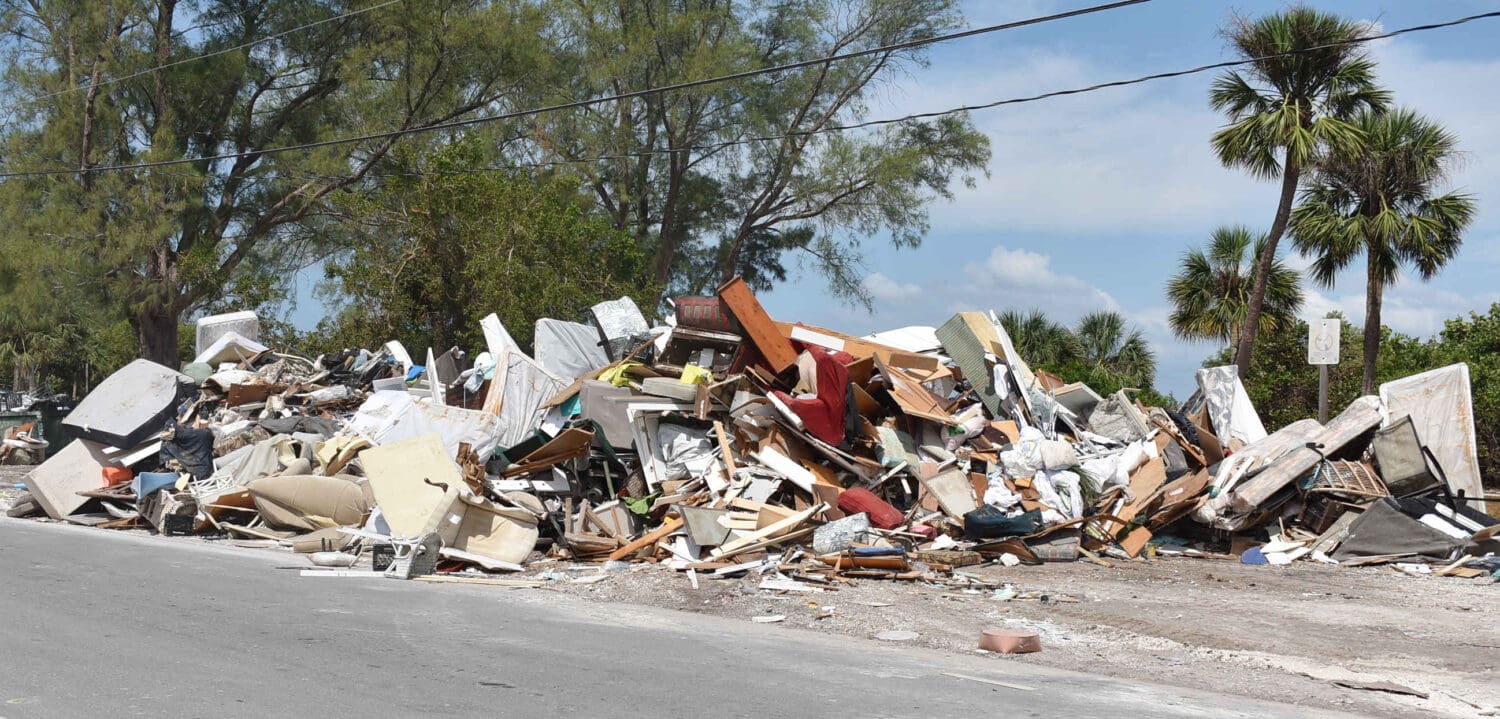
Anna Maria’s debris removal strategy includes using the Bayfront Park parking lot along North Bay Boulevard as a centralized debris collection and processing area. The debris initially deposited there is later transported to the county landfill.

Anna Maria debris removal nearly complete, deadline set
Bayfront Park is being used as a makeshift debris collection and processing area. – Joe Hendricks | Sun

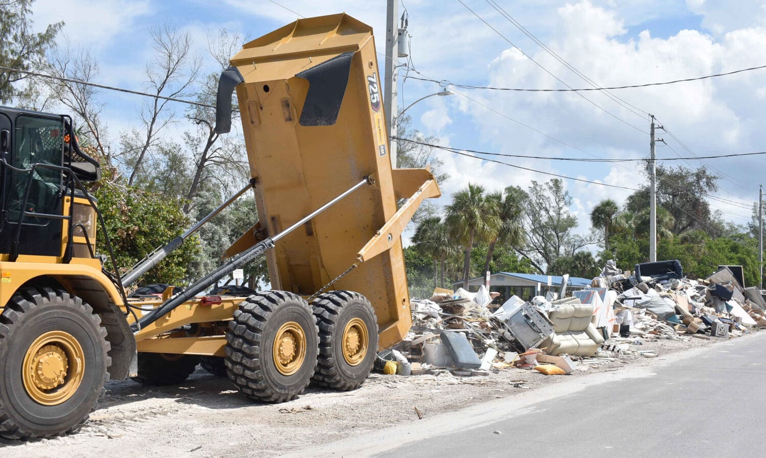
“We put an average of 68 trucks on the road hauling debris out of the city of Anna Maria. We took over 400 loads to the landfill. We took a total of 1,432 tons of debris, and that’s mostly household debris. There’s still landscaping debris. We’ve started to make a dent on that. Now there’s more household debris coming in, but we’ve made significant progress,” Murphy said on Thursday.

“We get a load ticket when they leave here, we get a load ticket when they go to the dump and we track all that. It’s all very closely monitored so we don’t get short-changed,” he added.

Anna Maria debris removal nearly complete, deadline set
The debris deposited at Bayfront Park is later transported to the county landfill. – Joe Hendricks | Sun

Murphy said the city already spent approximately $750,000 on debris removal and he anticipates the final cost to be around $1.5 million. City Clerk LeAnne Addy said the city usually receives 50% reimbursement within three days of requesting it and Murphy said the remaining reimbursement comes later.

Anna Maria debris removal nearly complete, deadline set
Some hurricane debris remained along Anna Maria streets on Oct. 15. – Joe Hendricks | Sun

“I don’t think we deserve any gold stars. We still have a long way to go and we’ve only done what’s expected of us. We’re going to get reimbursed for it. We’ve done everything by the numbers,” Murphy said of the city’s efforts.

Regarding the city’s financial position, Murphy said the city currently has $1.5 million in its checking account and an additional $3.5 million in reserves.

Morton’s comments

On or around Oct. 15, Nikki Gibson posted the following message on the Island Ratz Unite Facebook page regarding the city of Holmes Beach’s debris removal efforts: “For heaven’s sake,  how much more do we have to put up with on Holmes Beach? The emotional stress of having this constant reminder of what we have all had to endure is taking its toll. Where are the people upon whom we are supposed to rely?”

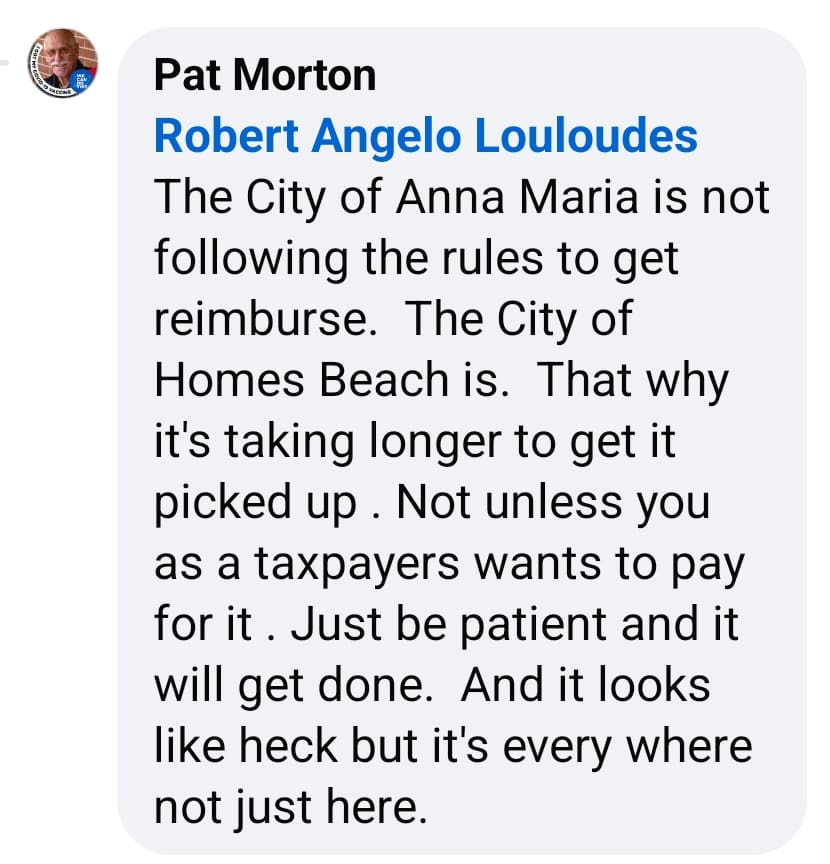
In response, Morton posted this comment: “The city of Anna Maria is not following the rules to get reimburse (sic). The city of Homes Beach is. That (sic) why it’s taking longer to get it picked up. Not unless you as a taxpayers (sic) wants to pay for it.”

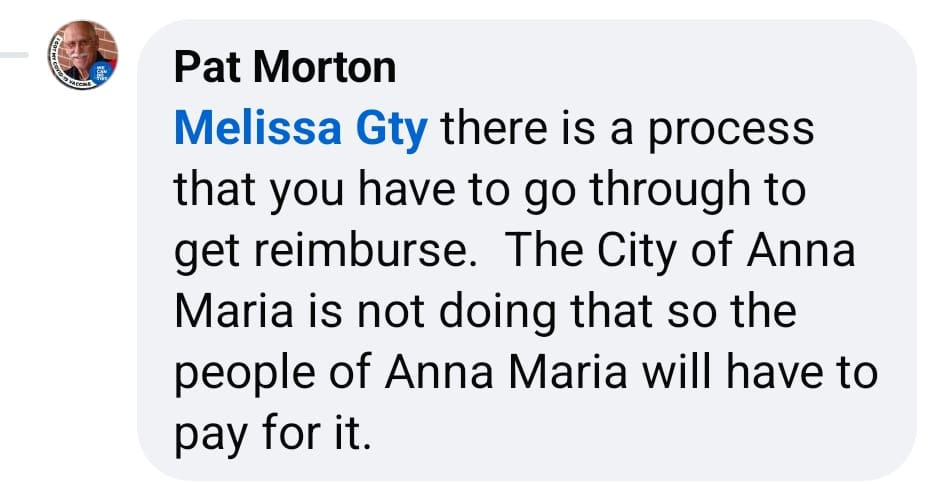
Morton also posted this comment: “There is a process that you have to go through to get reimburse (sic). The city of Anna Maria is not doing that, so the people of Anna Maria will have to pay for it.”

Regarding those comments, Murphy said, “There’s people circulating malicious rumors about reimbursement. We have followed every guideline and every rule and I am sick and tired of hearing it. This is not a new allegation. After Hurricane Irma, I was told the same thing. We had our debris removed and we got reimbursed. We used the same methodology and the same players for Hurrian Irma, Hurricane Ian, Hurricane Idahlia, Hurricane Debby, Helene and now Milton. We know what we’re doing.”

During public comment, former city commissioner and current mayoral candidate Brian Seymour said he’s driven by the Bayfront Park processing area several times and witnessed those workers following FEMA’s debris separation guidelines.

Regarding Morton’s comments, Seymour said, “Worry about your own city. Worry about your problems down there.”

Commissioner Mark Short, also a mayoral candidate, said Morton’s comments were an act of “deflection.”

Tracking Hurricane Idalia

Tuesday, Aug. 29, 5 p.m. UPDATE:

MANATEE COUNTY – Hurricane Idalia has been upgraded to a Category 2 storm with maximum sustained winds of 100 miles per hour. The storm is anticipated to continue to impact Anna Maria Island and the surrounding area this evening and overnight. County officials warn that the greatest risk the storm poses to this area is the chance for tornadoes to spawn from the hurricane and storm surge combined with a king tide expected to come in tomorrow morning at 11:30 a.m. Currently, NOAA shows that Anna Maria Island, Cortez and coastal areas of west Bradenton remain in the 4-7 foot peak surge warning zone.


Tuesday, Aug. 29, 3 p.m. UPDATE:

MANATEE COUNTY – Hurricane Idalia is classified as a Category 1 storm with sustained winds of 90 mph near its core. The storm is forecast to increase in strength to a Category 3 storm before making landfall. Currently, the hurricane is anticipated to make landfall mid-morning Aug. 30 near Cedar Key.

The outer bands of Idalia are bringing rain to the area. Anyone choosing to stay on the Island are asked to avoid driving through flooded areas and to shelter in place as the storm moves through the area.

A significant storm surge is expected with Hurricane Idalia. Due to a king tide expected Wednesday, Aug. 30 around 11:30 a.m., the highest storm surge is expected tomorrow morning. County officials advise residents and visitors to continue to shelter in place through tomorrow’s high tide. NOAA predicts 4-7 feet of storm surge for Anna Maria Island.

Hurricane Idalia storm surge forecast
Hurricane Idalia is expected to bring 4-7 feet of storm surge to Anna Maria Island. – Submitted

NOAA predicts sustained winds of 35 mph with wind gusts up to 50 mph for coastal Manatee County. County officials note that once winds reach a sustained 35 mph or roads become impassible due to flooding, first responders will not be able to respond to emergency calls.

There will be no trash pickups today or tomorrow. Recycling and yard waste pickups are canceled for the week.

Currently, there are no plans to cut water or other utilities to Anna Maria Island. Anna Maria Mayor Dan Murphy said that water will be shut off if Hurricane Idalia reaches a Category 3 designation or storm surge is expected at 7 feet or higher.

Holmes Beach Police Chief Bill Tokajer said that the drawbridges would not be raised at any time to prevent people from leaving the Island during the hurricane.

There will be no trash pickups today or tomorrow. Recycling and yard waste pickups are canceled for the week.

MANATEE COUNTY – Hurricane Idalia is on a collision course with the west coast of Florida. The Sun is committed to giving you the latest updates as the storm moves closer to Anna Maria Island.

County officials issued a press release at 9:37 a.m. today including newly announced closures. Manatee County Area Transit buses will stop operations at 2 p.m. today or earlier if weather conditions call for an earlier suspension of service. Transportation services will remain suspended until it is safe to restart them.

Level A residents and visitors, including everyone living in mobile homes, Anna Maria Island, Perico Island, Flamingo Cay, waterfront areas of west Bradenton, and Cortez, are under a mandatory evacuation with Level B residents and visitors under a voluntary evacuation notice. All residents who evacuate are reminded to take their re-entry tag issued from their city in order to gain access to the Island after the storm passes. Anyone who chooses to shelter in place on the Island is advised that all first responders and emergency personnel will be grounded once winds reach a sustained 45 mph.

County officials warn that while wind and rain are expected as Hurricane Idalia moves closer to the west coast, the major cause for concern is storm surge, which could happen near an already expected king tide on Wednesday. As of a 4 a.m. update, NOAA was projecting a storm surge near Anna Maria Island of 4-7 feet.

Hurricane Idalia surge
The current peak surge forecast for Hurricane Idalia as of 4 a.m. on Aug. 29. – Submitted

Sandbagging stations are open at Bayfront Park in Anna Maria, City Field in Holmes Beach, Coquina Beach in Bradenton Beach and GT Bray on 59th Street in Bradenton.

All Manatee County libraries are closed until Thursday, including book drops.

All Manatee County schools are closed until Thursday morning at this time pending assessments after the storm passes.

Emergency shelters are open for those who need them. Shelters should be considered a last resort and anyone who can is asked to shelter in place with friends or family outside of the evacuation zone. A list of open shelters can be found online. If going to a shelter, take bedding, food, water, medications and other supplies to last for at least three days. Note that not all shelters are pet-friendly. If you’re taking a pet, make sure the pet has a crate, food, water, leash, litter box (if needed) and any other supplies necessary for a three-day stay. All pets must be accompanied by their owners and owners must furnish proof of recent vaccinations.

Manatee County officials are scheduled to give a 3 p.m. update from the Emergency Operations Center which can be viewed live on YouTube and Facebook.

While Idalia is not currently forecast to make a direct impact on Anna Maria Island, county officials warn residents and visitors to keep an eye on the weather and watch as models of the path of the storm are updated throughout the day. Keep checking back to this post for the most up-to-date information from The Sun.

Season’s first named storm bypasses AMI

Season’s first named storm bypasses AMI

ANNA MARIA ISLAND – Hurricane season is officially underway. This year’s June 1 start was heralded with the arrival of Tropical Depression Two, which formed into Tropical Storm Arlene the next day.

Though short-lived, Arlene was a good reminder that Atlantic hurricane season is here and now is the time to get prepared, not when the Island is facing the threat of storm impacts.

Here are some tips to help you get ready for hurricane season.

  • Have a 3–5-day supply of non-perishable food and water for each member of your family, including pets.
  • Keep emergency medical supplies, including medications, a first-aid kit and hand sanitizer.
  • Have a supply of battery-powered lanterns and flashlights, along with extra batteries.
  • Make copies of important documents, such as wills, passports, photo identifications, veterinary records for your pets and insurance policies. Keep the copies in an easy-to-access place where they can be grabbed quickly in case of an evacuation.
  • Keep a stock of cleaning supplies such as trash bags, rubber gloves, sanitizing cleaners or wipes and paper towels handy.
  • Invest in a fire extinguisher.
  • Pick up a battery-powered or hand-crank radio to listen for news when the electricity goes out.
  • Keep your yard and patio areas clean and clear of debris to make moving everything outside that could blow away or cause damage during a storm easier.
  • Know your evacuation zone. Anna Maria Island, Perico Island, Flamingo Cay, Cortez and parts of northwest Bradenton are all in the first evacuation zone for Manatee County. Make a plan with relatives or friends outside of early evacuation zones in case you need to leave home. In the event of an evacuation, you should plan to evacuate a few miles, not a few hundred miles, so that you can get back and check on the condition of your property after the storm passes and local officials determine it’s safe to return to the area.
  • If you have a generator, make sure to give it a test run before a storm comes toward Manatee County, that it’s kept in a safely ventilated area and that all carbon monoxide alarms are in good working order.

For anyone who finds themselves in need of hurricane supplies, Florida has two tax-free holidays to help with the purchase of some items. The first tax-free holiday ends on Friday, June 9. The second tax-free shopping opportunity will be from Aug. 26 to Sept. 8. Included items include portable generators, waterproof sheeting, smoke and carbon monoxide alarms, portable power banks, batteries, flashlights, coolers, portable radios and more. A full list can be found online.

For more information on preparing for hurricane season, visit the Ready website.

Hurricane Expo stresses preparedness

Hurricane Expo stresses preparedness

PALMETTO – Even though Anna Maria Island and most of Manatee County dodged the worst of Hurricane Ian last year, there were still plenty of lessons learned, and the community was reminded of how much of a threat a major hurricane is to the area, especially those living on the barrier islands like AMI.
Even with the storm turning in its final hours of approach to the Island, many still went close to a week without power and there was significant wind damage. To help the community be better prepared for future hurricanes, Manatee County hosted the Third Annual Hurricane Preparedness Expo on May 18 at the Bradenton Area Convention Center in Palmetto.

The expo featured more than 50 booths with valuable information about how to survive a storm. There was plenty to take away from the event, but the theme echoed by most experts was to be prepared, take watches and warnings seriously, and when told to evacuate, to do so as quickly as possible.

There were rescue vehicles from multiple agencies that do search and rescue in the county, law enforcement was on hand to answer questions and dozens of vendors were on hand to answer questions about everything from stormproof doors and windows to how to take care of pets during a disaster.

“We begin to mobilize long before a major storm hits the area,” said Gary Weinstein, of the Red Cross Manatee County. “Getting food, water, medical supplies and other anticipated post-disaster necessities is vital to help those in need after the storm.”

Carolyn Nielson of the Manatee County Salvation Army echoed the Red Cross regarding being prepared and being ready to step in when needed. The Red Cross had its relief truck on hand at the event.

“We come out and not only get food and water to people in the community that need us, but we also serve first responders and those helping in the effort after a storm who work long hours to serve others,” Nielson said.

Sun Coast Blood Center was on hand as well, and stressed the need to give blood before a disaster hits.

“It takes a bit of time for blood donated to be processed, so waiting until after a disaster isn’t the best option,” Sun Coast Blood Center’s Whitlie Turner said. “Now, before hurricane season, is when we really encourage people to come out and give blood.”

Hurricane season’s second half could be unusually active

Hurricane season’s second half could be unusually active

CORTEZ – Halfway through a quiet hurricane season, it’s too soon to relax, as experts are still predicting above-normal 2022 Atlantic hurricane activity.

Atmospheric and oceanic conditions still favor an above-normal 2022 Atlantic hurricane season, according to the National Oceanic and Atmospheric Administration’s (NOAA) annual mid-season update, issued this month by the Climate Prediction Center, a division of the National Weather Service. The hurricane season runs from June 1 to Nov. 30.

A timely rotating exhibit currently at the Florida Maritime Museum (FMM) titled “Caught in the Storm: 100 Years of Florida Hurricanes” revisits some of the worst coastal storms to impact the state – several of which hit locally.

An unnamed hurricane in October 1921 covered the Gulf coast in water from Fort Myers to Tarpon Springs, causing devastation to the Cortez waterfront.

“In Cortez, fishermen watched their industry be nearly swept away. The storm’s waves left behind mounds of debris tangled in nets where fish camps and docks once stood,” according to the FMM exhibit. “Left without markets to sell to, the fishermen created their own, some of which still remain on Cortez’s waterfront.”

The Cortez Public School, which still stands at 119th Street West and Cortez Road and is now the Florida Maritime Museum, is the highest point in Cortez and was used as a shelter during that storm, which had an 11-foot storm surge.

In October 1944, a major unnamed hurricane known unofficially as the Cuba-Florida Hurricane “struck the Bradenton/Sarasota area causing trees to fall across the road taking out power lines and disrupting all communications between the Keys and the mainland.”

Hurricane Alma in June 1966 was another storm highlighted in the exhibit, with the following recollection from Cortez resident August Antilla, “…by nightfall Ellen and I had purchased $12 worth of cheeses, cold cuts and candy, and we were looking forward to our cozy hurricane party, just the two of us. The radio was blaring continually… ‘Evacuate, Anna Maria Island. The tide will be 7 to 11 feet above normal.’ ”

The largest hurricane evacuation in U.S. history happened just five years ago in September, 2017 with 6.5 million people fleeing their homes in anticipation of Hurricane Irma. Hurricane track predictions included a “cone of uncertainty” with Irma; that cone covered the entire Florida peninsula. In an abundance of caution, many counties issued mandatory evacuation orders.

So far this year, the season has seen three named storms – Alex, Bonnie and Colin – and no hurricanes in the Atlantic. An average hurricane season produces 14 named storms, of which seven become hurricanes, including three major hurricanes.

NOAA forecasters have slightly decreased the likelihood of an above-normal Atlantic hurricane season to 60% from the May prediction of 65%, but more than 60% of hurricanes that make landfall do so after the peak of the season in September.

“We’re just getting into the peak months of August through October for hurricane development, and we anticipate that more storms are on the way,” NOAA Administrator Rick Spinrad said.

“I urge everyone to remain vigilant as we enter the peak months of hurricane season,” U.S. Secretary of Commerce Gina Raimondo said.

For more information, check out The Sun’s Hurricane Guide.

Prepare your boat for a hurricane

Prepare your boat for a hurricane

As a storm approaches, don’t neglect to protect your boat.

  • Make a plan well in advance to secure your boat during a hurricane.
  • Small, open boats and high-performance powerboats with low freeboard should be trailered and transported inland.
  • Boats ashore should be stored well above the anticipated storm surge.
  • Reduce windage as much as possible. Dig a hole for your sailboat keel or lay smaller sailboats on their sides.
  • Make sure your boat has extra jack stands, at least three or four on each side for boats under 30 feet and five or six for larger boats. The jack stands should be supported by plywood and chained together.
  • Strap boats down to eyes embedded in concrete or earth augers.
  • Boats in the water should be secured in a snug harbor. Boats on lifts should be tied to the lifts.
  • At a marina, use sturdy pilings and trees one or two slips away to secure boats using longer-than-normal dock lines.
Manatee County hurricane shelter list

Manatee County hurricane shelter list

The following hurricane shelters in Manatee County may be open depending on the direction and size of the storm. There are no assigned shelters, and few are furnished, so bring lawn chairs, cots, bedding and folding tables.

Bayshore Elementary School – 6120 26th St. W., Bradenton

Braden River Middle School – 6215 River Club Boulevard, Bradenton

Braden River High School – 6545 S.R. 70 E., Bradenton*

Buffalo Creek Middle School – 7320 69th St. E., Palmetto

Daughtrey Elementary – 515 63rd Ave. E., Bradenton

Freedom Elementary School – 9515 S.R. 64 E., Bradenton

Gullett Elementary School – 12125 44th Ave. E., Bradenton

Haile Middle School – 9501 S.R. 64 E., Bradenton

Harvey Elementary School, 8610 115th Ave. E., Parrish

Johnson-Wakeland School – 2121 26th Ave. E., Bradenton

Kinnan Elementary School – 3415 Tallevast Road, Sarasota

Lee Middle School – 4000 53rd Ave. W., Bradenton

Manatee High School – 1000 32nd St. W., Bradenton*

McNeal Elementary School – 6325 Lorraine Road, Bradenton

Miller Elementary School – 601 43rd St. W., Bradenton

Mills Elementary School – 7200 69th St. E., Palmetto*

Myakka City Elementary School – 37205 Manatee Ave., Myakka City

Oneco Elementary School – 5214 22nd St. Court E., Bradenton

Prine Elementary School – 3801 Southern Parkway, Bradenton

Rogers Garden Elementary – 515 13th Ave. W., Bradenton

Seabreeze Elementary School – 3601 71st St. W., Bradenton

Tillman Elementary School – 1415 29th St. E., Palmetto

Williams Elementary – 3404 Fort Hamer Road, Parrish

Willis Elementary School – 14705 The Masters Ave., Bradenton

Witt Elementary School – 200 Rye Road, Bradenton

*Pet-friendly

Manatee County logo

Special needs help available

Help is available for those dependent on medical equipment or those who need assistance or transportation to a shelter by registering in advance. Register for Manatee County’s Special Needs Assistance Program in several ways:

  • Call the county’s emergency management department at 941-749-3500, ext. 7828, and an application will be mailed to you. Complete the form and return it to Manatee County Emergency Management, P.O. Box 1000, Bradenton, FL 34206-1000.
  • Go to the county’s website and click on “emergency management” and then on “special needs registry” to download instructions, an evacuation checklist, and an application. Complete the form and return it to Manatee County Emergency Management, P.O. Box 1000, Bradenton, FL 34206-1000.
  • Register online at the county’s website, https://mymanatee.org

Busy hurricane season predicted

The forecasters at Colorado State University’s Tropical Weather and Climate Research department predict a busier than average 2022 hurricane season for the Atlantic basin, including the Gulf of Mexico. The season could spawn 19 named storms with nine of those turning into hurricanes and four becoming major hurricanes.

To be named, a storm must have wind speeds of 39 mph or higher with a circular rotational pattern. Hurricanes are named storms with winds of 74 mph or higher while a major hurricane is considered one that ranks as a category 3, 4 or 5 storm with wind speeds beginning at 111 mph.

Forecasters anticipate that with increased water surface temperatures in the Caribbean and subtropical Atlantic seas, there is an above-average chance of major hurricanes making landfall along the southern U.S. and in the Caribbean.

The forecasters at the National Oceanic and Atmospheric Administration’s Climate Prediction Center are predicting yet another busier-than-average Atlantic hurricane season, with the possibility of 13-20 named storms, six to 10 hurricanes and three to five major hurricanes classified as Category 3, 4 or 5.

To be named, a storm must have wind speeds of 39 mph or higher with a circular rotational pattern. Hurricanes are named storms with winds of 74 mph or higher, while a major hurricane is considered one that ranks as a Category 3, 4 or 5 storm with wind speeds of 111 mph or higher.

NOAA forecasters also predict a 60% chance of an above-normal hurricane season, a 30% chance of a near-normal season and a 10% chance of a below-normal season. Reasons for the predictions include above-average ocean surface temperatures in the Atlantic Ocean and the Caribbean, no El Nino conditions to suppress hurricane formation and a possible return of La Nina conditions later in the season.

Atlantic hurricane season runs from June 1 to November 30.

Tips for surviving hurricane season

It’s easy to forget things when a hurricane is coming. Here are some reminders:

  • Plan where you will evacuate in advance, and tell friends or family in other states.
  • Register special needs residents in advance for county transportation to evacuation shelters.
  • Check your insurance policies – wind, flood and liability – to make sure they are in effect.
  • Find the elevation of your home at www.my.manatee.org.
  • Anna Maria Island residents and business owners should obtain or locate their re-entry tags from their city before evacuating. They are available at Anna Maria City Hall, Bradenton Beach City Hall and the Holmes Beach Police Department. One tag per residence or business is issued.
  • Consider buying a generator; ethanol-free gas to power generators is available at marinas.
  • Find out where sandbags will be provided and stock up.
  • Vacation rental agents should provide a hurricane guide in each rental unit during hurricane season.
  • Bridges to Anna Maria Island may be closed as a hurricane approaches and water and electricity may be shut off, so evacuate when ordered.
  • Turn off water, electric and gas mains when you leave to avoid broken pipes.
  • Bring medicines, cash – both paper and coins for vending machines – and disaster kits to shelters.
  • Research how to turn your cell phone into a wi-fi hotspot before you lose cell service.
  • Research how to extend battery life on your cell phone before the battery goes dead or buy a spare battery pack for your phone; remember, you can also charge your phone in your car.

2021 Atlantic hurricane season names

Each year the World Meteorological Organization releases one of six lists of names for Atlantic tropical storms and hurricanes. If this year’s names sound familiar, that’s because they were last used in 2015. This year’s list will move back into rotation in 2027.

If a storm is particularly devastating, the name may be retired, like Hurricane Katrina, and replaced with a new name. If a hurricane season is particularly active and more than 21 storms form, the additional storms are named after letters in the Greek alphabet.

To be named, a storm has to have wind speeds of at least 39 miles per hour and have a rotating circular pattern.

This year’s names are:

  1. Ana
  2. Bill
  3. Claudette
  4. Danny
  5. Elsa
  6. Fred
  7. Grace
  8. Henri
  9. Ida
  10. Julian
  11. Kate
  12. Larry
  13. Mindy
  14. Nicholas
  15. Odette
  16. Peter
  17. Rose
  18. Sam
  19. Teresa
  20. Victor
  21. Wanda
Where to get weather alerts

Where to get weather alerts

Here are several ways to receive up-to-date information about severe weather.

  • Go online to the Florida Division of Emergency Management (FDEM) website. From there, Floridians can sign up for electronic severe weather alerts specific to their community.
  • Buy a weather radio, preferably one that uses batteries and has crank-power capabilities. Radio stations broadcast continuous updates and weather-related safety information from the closest National Weather Service office.
  • Call the FDEM State Assistance and Information Line, or SAIL, at 800-342-3557. FDEM activates the toll-free hotline during emergencies.
  • Connect with local emergency managers on social media. Manatee County has an emergency management office that’s active on social media. Follow them on Twitter or Facebook to get severe weather updates.
  • Connect with FDEM on social media. Follow FDEM on Twitter @FLSERT and find them on Facebook.
  • Enable Wireless Emergency Alerts on mobile devices. Many cell phones are capable of receiving automatic WEAs that provide local emergency alerts. Floridians can receive WEAs at all times since cell network congestion does not affect messages and providers offer the service for free.
  • Pay attention to local media. Local radio, television, newspapers and websites are great sources for continuous weather updates and advisories.


County advises AMI to shelter in place or voluntarily evacuate

County advises AMI to shelter in place or voluntarily evacuate

Updated Nov. 11, 2020 at 2 p.m. – ANNA MARIA ISLAND – As Tropical Storm Eta approaches, Manatee County public safety officials are recommending that Anna Maria Island residents shelter in place if possible, but a voluntary evacuation notice has been issued for Manatee County’s island communities and other low-lying areas.

Eta was downgraded from hurricane status to a tropical storm at 1 p.m.

Hurricane Eta was downgraded to tropical storm status at 1 p.m.

During a virtual press conference this morning, when it was noted Tropical Storm Eta had been upgraded to a hurricane, Manatee County Public Safety Director Jacob Saur said he expected the storm to be downgraded to a tropical storm again before its expected landfall north of Tampa. But he noted there’s only a 5 mph difference in windspeeds between a tropical storm and a hurricane.

Saur said the worst local conditions are anticipated later this evening and throughout the night. He added there’s a possibility of a 2-4 foot storm surge along the barrier islands and possible wind speeds ranging from 50-75 mph.

The Anna Maria City Pier parking lot is flooded this afternoon as waves break against the Tampa Bay shoreline. – Cindy Lane | Sun

Saur said fallen trees, downed power lines and the loss of power are likely throughout the county.

“Our biggest concern is storm surge,” Emergency Management Chief Steve Litschauer said.

When asked what residents should do regarding their storm preparations, Saur said, “Now is the time to prepare. This is a fast-moving storm and it sped up. Now is the time to make their plan. They should expect power outages throughout the night and into the morning. They should make plans for that,” Saur said.

He recommends picking up last-minute food items if needed and walking your yard to clear it of any loose items that could become airborne in high winds.

“Late afternoon or early evening they need to be where they’re going to be. The sooner the better. By late afternoon and this evening they need to be where they’re going to be,” Saur said.

He said all of the public beaches on Anna Maria Island are being closed today and going into the water is not recommended.

Saur said he does not expect the storm’s impact to be as great in the eastern portions of Manatee County, but the impacts will still be felt.

Litschauer said the county is opening two emergency shelters today that should be viewed as “refuge of last resort” because of the COVID-19 pandemic.

The closest emergency shelter to Anna Maria Island is Manatee High School, located at 902 33rd St. W. in Bradenton. A second shelter is being readied and opened at Mills Elementary School in Palmetto, located at 7200 69th St. Both shelters are pet friendly.

The two shelters will have limited capacity due to the COVID-19 pandemic. Masks are required and will be provided to those who need them. Litschauer said due to the COVID-19 concerns, these public shelters should only be used as a last resort.

Those going to a shelter are asked to bring their own bedding, chairs and other needed items.

“Masks will be mandatory. We want to enforce social distancing too,” Litschauer said.

Due to the pandemic, capacity at both shelters will be limited. Litschauer said the normal shelter capacity at Manatee High School is 1,853 and that has been reduced to 617 people because of the pandemic. He said the normal capacity at Mills Elementary is 1,484 people and that has been reduced to 989 people.

Closures and updates

The COVID-19 testing site at the Bradenton Area Convention Center will temporarily close today at noon.

All Manatee County Area Transit (MCAT) operations will be suspended today by 1 p.m.

The Island Branch Library will be closed tomorrow.

Robinson and Emerson Point Preserves will be closed today and tomorrow.

Tomorrow’s Planning Commission meeting has been postponed to Thursday, Nov. 19.

Trash collections are expected to remain on schedule in unincorporated Manatee County.

The World’s Strongest Man Competition scheduled this week on Anna Maria will be moved to the Feld Entertainment Campus and will not be open to the public.

Sandbags

Sandbags are available at Bayfront Park in Anna Maria, at the Holmes Beach Public Works building and at Coquina Beach in Bradenton Beach. In Bradenton, sandbags are available for Bradenton residents only from 9 a.m. to 5 p.m. at the public works annex building at 1411 Ninth St W.

More information on shelters, sandbags and the approaching storm is available at the Manatee County website, and on the county’s social media platforms. The county 311 line is in operation to answer questions county residents and visitors have regarding the storm.

Manatee County Information Outreach Manager Nick Azzara said MCAT is suspending all bus service today at 1 p.m. and a decision will be made tomorrow (Thursday) as to when those services will resume.

He said the COVID-19 testing at the convention center in Palmetto is being suspended at noon today and may resume tomorrow, depending on the weather.

“Strong winds and storm surge are the main concerns with this storm,” Azzara reiterated.

Tropical storm force winds are expected to arrive in the Manatee County area this afternoon and continue through the night.

“This afternoon, conditions are going to start deteriorating. It’s going to be a rough night. It’s going to be a rough morning and then it will start to clear in the afternoon,” Saur said.

Michael Barber from the Manatee County School District said county schools are closed today in honor of Veterans Day and due to the storm will remain closed Thursday and Friday.

“We are still going carry on e-learning,” Barber said. “We plan to still be having school over these next two days.”

Castles in the Sand

What’s in a hurricane name?

Every year at this time we steady our nerves and go forward into hurricane season which tortures us from June 1 to Nov. 30. Not all storms during hurricane season are actually hurricanes; some of them are tropical storms, which can be just as deadly. But what about the names we give to these storms? Have you ever thought about how this happens?

First of all, a tropical system is named when it maintains sustained wind speeds of 39 miles per hour at which point it is officially a tropical storm. Many named systems never reach hurricane status, which is 74 miles per hour. Hurricanes and tropical storms began being named in 1953 in an effort to more easily identify specific storms when there are two or more systems active at the same time.

The storm names were originally only female until 1978 when male names were added. Names are in alphabetical order excluding Q, U, X, Y and Z and alternate between female and male names. Names are recycled every six years, and storm names that were particularly deadly or costly are retired and replaced. Thankfully, we’ll never have another Irma.

This year the names for the Atlantic Ocean storms are a repeat of 2013, the names are Andrea, Barry, Chantal, Dorian, Erin, Fernand, Gabrielle, Humberto, Imelda, Jerry, Karen, Lorenzo, Melissa, Nestor, Olga, Pablo, Rebekah, Sebastien, Tanya, Van and Wendy.

The first forecast for this hurricane season from Colorado State University is five storms with two of them reaching major hurricane strength. This is based on the cooler than normal sea surface in the tropical Atlantic Ocean providing less fuel for tropical cyclone formation and intensification. None of this, however, should encourage you to let your guard down; one of these two major hurricanes could easily have our name on it.

It’s time to assemble a hurricane kit that will help you if you stay in your home without power and also be portable if you have to evacuate. You should include three days’ worth of non-perishable food and water per person, a first aid kit, personal hygiene items, flashlights and batteries, a battery operated radio, cash and important documents (insurance policies and photos of your home, vehicles and vessels). Additional supplies can include a manual can opener, matches, books, games, pet supplies, coolers and ice packs and, most important of all, an evacuation plan for you and your family. For the plan, you should compile a list of hotels to evacuate to, as well as those that accept pets.

Batten down the hatches in your home by covering windows with shutters or wood, trim trees prior to storms, reinforce garage doors and bring in outdoor furniture and anything else that can blow into windows or siding. Tie down your boat with extra lines and remove canvas and sails that can unravel in a storm. Be prepared for the loss of power for a few days or longer. Make sure your cars have full tanks of gas and cell phones are fully charged. Fill bathtubs prior to a storm so there is water available for toilets in case water mains are impacted and again get some cash since ATM machines and banks will likely also be out of power.

Finally, my personal hurricane preparedness strategy is to not have a lot of food in the refrigerator, particularly raw frozen food. If a storm is coming, cook anything you can prior to the storm. It will last in coolers for a longer period of time and you don’t have to worry about rotting food in the refrigerator if you need to evacuate. Those of us who have lived in Florida for a long time are pros when it comes to hurricane season, however, it can never hurt to remind ourselves what needs to be done. Let’s hope we never get to Wendy, and she lives to be reinstated in six years. Stay safe.

More Castles in the Sand:

Falling in love with a second home

One of our favorite topics

Floods, saltwater and freshwater