
Tag: Sandpiper Resort

Pines’ residents devastated by damage, ‘uninhabitable’ homes

Pines’ residents devastated by damage, ‘uninhabitable’ homes

BRADENTON BEACH – Pines Trailer Park residents Mary Mox and Lesley Mullaney are among those who’ve been told their mobile homes are considered uninhabitable, mostly due to flood damage sustained during Hurricane Helene.

Citing FEMA substantial damage guidelines and the city’s floodplain ordinance during the Oct. 17 city commission meeting, Bradenton Beach Building Official Darin Cushing offered his assessment that the flood-damaged mobile homes in the Pines Trailer Park are uninhabitable; as are the flood-damaged homes in the Sandpiper Resort Co-Op mobile park at the north end of the city.

After Thursday’s meeting, Mox and Mullaney sat on fellow Pines resident Joe Klingler’s swinging chair and lamented what’s transpired since back-to-back hurricanes struck the mobile home park they’ve long called home.

Trying to find a glimmer of joy in a devasting scenario, Mox and Mullaney joked about the amount of time they’ve spent on Klingler’s swing over the years.

“We’re the two old ladies that constantly bothered him, and he loves it,” Mullaney said.

Mox, an Ohio native, lived in the Pines seven months a year. Mullaney, a New York native, lived there full-time and has no other home.

Pines’ residents devastated by damage, ‘uninhabitable’ homes
Many Pines Trailer Park residents attended Thursday’s city commission meeting. – Joe Hendricks | Sun

When asked about the city meeting, Mox said, “I was disappointed. I really was.”

“At one point I felt we were being scolded, and that they felt that it was all about them and how hard they’ve been working,” Mullaney said. “Yes, they’ve been working hard every day and night. I get it, but these are our homes. This is my only home.”

“How long do we have to sort through stuff to try to keep pictures and stuff like that?” Mox said. “We don’t know.”

“We don’t know anything. I feel defeated and sad,” Mullaney said.

“I feel very let down,” Mox said.

Pines’ residents devastated by damage, ‘uninhabitable’ homes
The watermarks on this home in the Pines Trailer Park show how high Hurricane Helene’s floodwaters rose. – Joe Hendricks | Sun

Mulaney and Mox hold little hope that park owner Shawn Kaleta and his investment partners will provide any assistance or relief.

“I think we all know that,” Mullaney surmised.

During Thursday’s meeting, a Pines resident noted many in the park had already paid their October lot rent by the time the back-to-back hurricanes struck.

“I was wondering if there was any way to get our money back from the owner,” one resident said. “Our places are unlivable.”

In response, Kaleta representative Sam Negrin said, “It seems there’s a misconception there is just one owner. There are over 10. It’s an investment conglomerate. We cashed the October rent checks because we still have to pay our very high mortgage on the property. This will have to come up for discussion and there will be compassion shown.”

Then, now, next

“My husband’s been coming here for 76 years. We’ve been married for 54 years,” Mox said. “We came every year with our kids and we bought in here 32 years ago. We have supported this Island with our hearts and souls and the gal that spoke up for us at today’s meeting is to be commended. She said everything perfectly. We’ve been working for two solid weeks, pulling stuff out and trying to do things right and no one ever came along and said you might want to hold up. Basically, we’re out here by ourselves with no guidance from anybody.”

“My mom lived in #2 for over 17 years,” Mullaney said. “My husband and I would come down on vacation. We just loved it here. We couldn’t wait until we retired so we could buy a place here, and that’s what we did. I’m glad my husband just passed away because this would have killed him. He loved this place.”

Pines’ residents devastated by damage, ‘uninhabitable’ homes
These were among the more colorful mobile homes in the Pines Trailer Park. – Joe Hendricks | Sun
Pines’ residents devastated by damage, ‘uninhabitable’ homes
The mobile home on the left bears the moniker “Reel Lucky” and the one on the right says, “One more day.” – Joe Hendricks | Sun

Mox is currently staying at a friend’s vacant mobile home in Palmetto. Mullaney didn’t say where she’s staying.

As for what’s next, Mullaney, said, “I have no idea. This is my only home. Everything’s gone. When the claw came to pick up the stuff that we had emptied from the house, it was just a sickening sound. It went right through your bones. It was awful. I keep thinking I’m going to wake up from this nightmare and it’s not happening. I’m just going to put on by ‘big-girl’ panties and move forward.”

(Sun reporter Leslie Lake contributed to this story. The Oct. 17 city commission meeting video is archived at the Anna Maria Island Sun Facebook page.)


Related coverage:

Sandpiper Resort evaluating FEMA guidelines, damage assessments

Pines, Sandpiper homes deemed uninhabitable


Pines, Sandpiper homes deemed uninhabitable

Pines, Sandpiper homes deemed uninhabitable

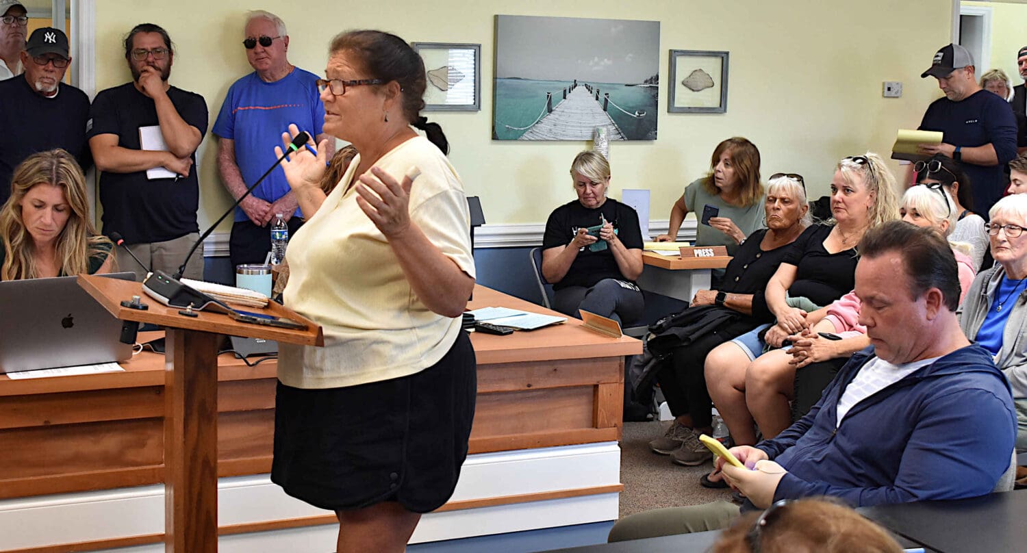
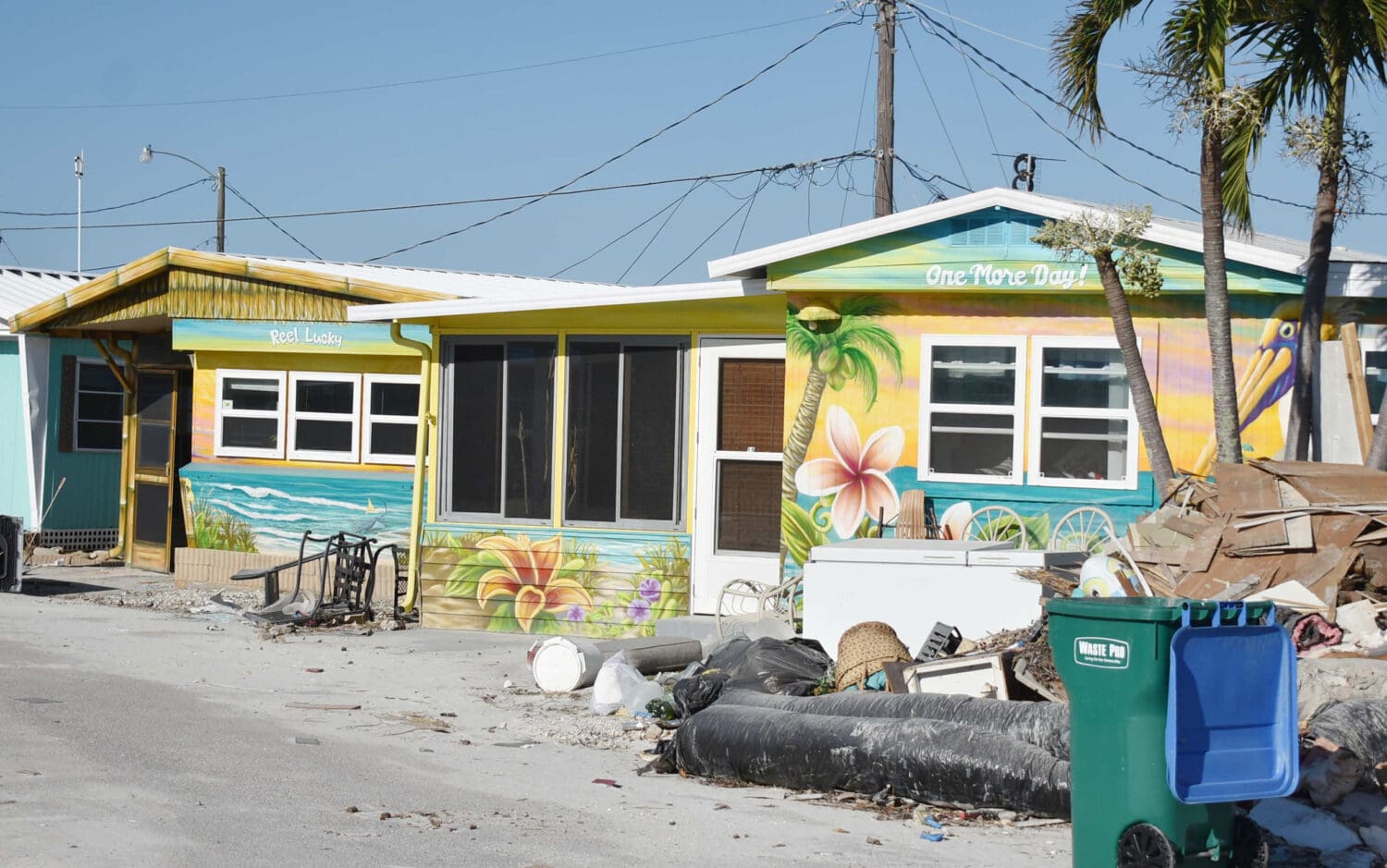
BRADENTON BEACH – At an Oct. 17 city commission meeting, Bradenton Beach Building Official Darin Cushing delivered the news he never wanted to give and mobile home residents never wanted to receive – that FEMA guidelines related to water intrusion from hurricanes have rendered the mobile homes at Pines and Sandpiper mobile home parks uninhabitable. Based on the city’s flood plain ordinance, the mobile homes could only remain if elevated to a height of up to 12 feet – an alternative Cushing said would likely not be economically or structurally feasible.

Cushing addressed the anxious residents who packed city hall chambers at the noon commission meeting.

“I’ve spoken with a lot of you out in the streets and over the phone and via text and emails for the last few days and weeks, we’ve gone back and forth a few times trying to find some way to get a good answer and a good solution, and this is not just the Pines but Sandpiper,” he said.

He then read his notes outlining FEMA guidelines:

“In accordance with FEMA’s damage assessment guide, there are different degrees of damage when it comes to mobile homes, or as they call them manufactured homes, and those different degrees of damage are affected, minor, major and destroyed. By these degrees of damage, all of the mobile homes in the Pines and many in the Sandpiper, but not all, have major damage by that guideline,” he said.

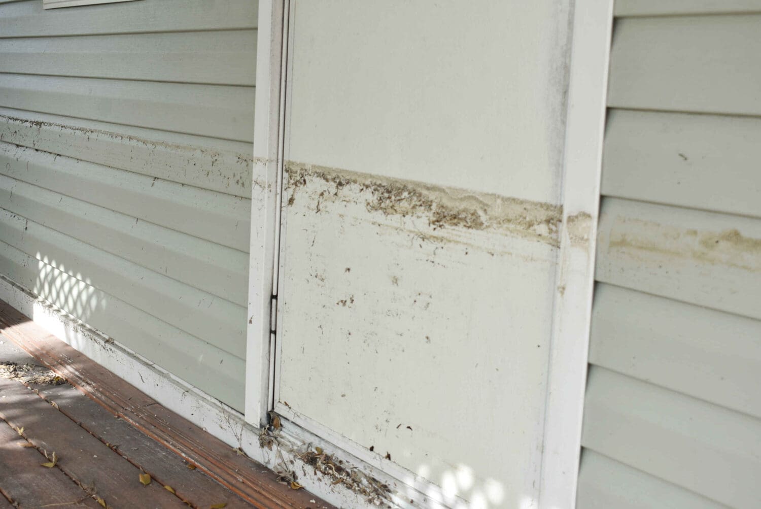
He said that major damage occurs when water covers the floor system and enters the living space of the residence, but is below the ceiling.

“There was some question whether major damage is the same as substantial damage. In speaking with FEMA representatives yesterday in person, that’s what they considered,” he said. “By this description, according to FEMA, the structure is considered to be substantially damaged and, in accordance with the city of Bradenton Beach flood ordinance, it says if an existing manufactured home has incurred substantial damage as the result of a flood it shall be elevated such that the bottom of the frame is at the Base Flood Elevation (BFE) plus three feet.”

The BFE at the Pines is nine feet. The BFE at the Sandpiper is seven or eight feet, depending on the section. Plus three feet would mean that homes at the Pines would need to be elevated to 12 feet with homes at the Sandpiper raised to 10-11 feet, depending on the section they’re located in.

“It would have to be on columns, on pilings into the ground, and all the other engineering that goes along with that. It appears to me that the engineering involved alone would cost more than the value of the structures,” Cushing said.

He said all utilities would have to be raised and stairs would have to be included. Permitting would be the responsibility of the property owner. In the case of the Pines, that would be local developer Shawn Kaleta and other unnamed investors.

“I don’t believe there’s a unit over there that structurally could withstand being 12 feet up in the air,” Cushing said.

The Pines has 86 units and Sandpiper Resort has 166.

Residents react

Residents’ reactions to the news ranged from strong emotions to offering alternative suggestions.

One Pines homeowner said she and her husband had bought a unit as an investment earlier this year.

“Are you telling me all that money is gone?” she asked.

“This is going to look like Pensacola, all the units will be in the air,” Eric Janson said.

“So according to your guidelines, every single-story structure that had water covering the floor is condemned?” James Hughes asked.

“This is specifically for manufactured homes,” Cushing said. “If a single-story home reaches that category of substantial damage, yes, they’re going to have to elevate. Commercial buildings have the option of flood-proofing.”

Elaine Armaniaco asked if the local ordinances could be changed.

“You’re redesigning the entire town,” she said. “Couldn’t you all get in some room and say hey, we need to rethink this? There has to be a little more brainstorming and a little more effort put into the creative process here of how we can save the entire character of this town, including the mobile parks, because based on what you’re saying now Bradenton Beach doesn’t exist. Let’s call this what it is. This is disastrous.”

“We did recently augment it,” Cushing said. “This ordinance was rewritten just in the last couple of years just for that very reason, to save this town, to save the buildings.”

Cushing said the buildings that are compliant with the floodplain ordinance received very little damage during recent hurricanes.

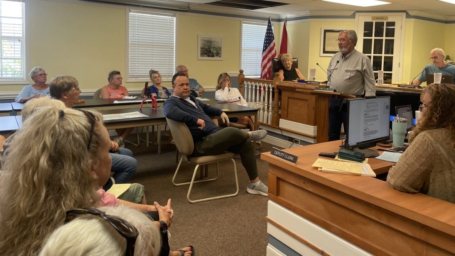
“We’ve all been here a long time and over the years, the building requirements have changed for everybody,” Mayor John Chappie said. “Everybody has been affected by the FEMA rules by the flood insurance guidelines.”

Cushing explained those guidelines.

“The city participates in what is called the community rating system, along with every city and county in the state of Florida for sure, and the rest of the country that has coastal water flood zones,” Cushing said. “It’s a system in which the city is graded by the federal government, FEMA and NFIP, the National Flood Insurance Program. Every year they come through to make sure that we’re following the rules that were sent down by the feds. If we were going to change rules they wouldn’t get less restrictive, they’d get more restrictive.”

The better the rating a city gets, the flood insurance rates are lowered, he said.

“It’s not something we just do arbitrarily. We have to follow those rules,” Cushing said.

50 Percent rule

“Basically their definition of substantial damage is – you’ve heard of the 50% rule,” Cushing said. “That rule says if damages to a structure are to a level such that it would cost 50% or more of the value of the structure to bring it back to its original condition, it has to be elevated to flood compliance and Florida Building Code.”

Cushing said as a flood plain manager, he is tasked with making that determination by either the property appraiser’s value or obtaining a private appraisal from the property owner.

“I get the flood insurance issue. These mobile homes, nobody has flood insurance,” Brett Williams said. “Two days ago you were going to come out to do a 50/50 assessment. All of a sudden you all decided you weren’t going to play it that way?”

Cushing said would take ownership of that, but that he was required to attend a Manatee County meeting with the Florida Division of Emergency Management (FDEM) and FEMA about damage assessment.

“At 8:30 yesterday morning I went to that training because it was required,” Cushing said. “Every building official in the entire county was there as well as multiple inspectors. There was a representative from FDEM and from FEMA.”

Cushing said he raised his hand at that meeting and asked specifically about mobile homes on the Island.

“The guy from FEMA told me if they got any water in them, that’s it, they’re toast. That’s basically what he told me,” Cushing said. “I don’t want to be the one to make this decision, but I am and I feel terrible for all of you and that’s where we are.”

City attorney Ricinda Perry said that every municipality in the state of Florida was given the same directive and requirements from FEMA.

“Will Manatee County be going to the trailer parks and mobile home parks that were affected by flood waters and having the exact same discussion about not being able to rebuild perhaps within the 50%?” Perry asked. “Is your information different from what Manatee County is going to be giving those parks?”

Cushing said the only differences would be related to each municipality’s and county’s floodplain ordinance.

“They’re all very similar,” he said. “I’ve lost sleep for the last three nights trying to figure out a way to make it so I didn’t have to tell you this, but this is what I have to tell you.”

Perry said the city is required to adopt a floodplain ordinance.

“The overriding purpose of the flood plain management regulations is to ensure that the participating communities take into account flood hazards to the extent that they are known in all official actions relating to land management or use,” Cushing said.

It’s not just Bradenton Beach, it’s all the communities, Chappie said.

At a resident’s suggestion that the Pines could be annexed from the rest of the city, Perry replied, “This is hard for all of us. I know our history and I know where all these mobile home parks came from. This isn’t something we take lightly. It’s my job to make sure we are following the laws even if we don’t like them. We have to abide by federal laws, federal regulations. The sovereignty of a municipality is absolutely trumped every single time by federal rules and law.”

FEMA will penalize the city if the city does not execute what is necessary to enforce their rules, she said.

Nearby communities

Genevieve McDonald asked about other nearby communities affected by flooding.

“It’s all starting to hit me all at once, but basically what you’re saying is all the mobile home parks in Manatee County are probably going to be condemned at some point?” she asked.

“I would say all the ones on the Island,” Cushing said. “The stuff on Cortez close to the river got the water we got on this side. I spoke to the Holmes Beach building official and he said any mobile homes there were gone.”

“The county is going to start their assessment of the three trailer parks right over the bridge this week, so they’re about to get the same news,” Police Chief John Cosby said.

Residents next steps and timeline

The residents in the park have paid their October lot fees.

“I was wondering if there was any way to get our money back from the owner,” one resident said. “Our places are unlivable. Every penny counts to us.”

Pine’s owner Shawn Kaleta’s representative Sam Negrin spoke.

“It seems there’s a misconception there is just one owner, there are over 10,” Negrin said. “It’s an investment conglomerate.”

Negrin said the mortgage holders for the property have been unwilling to provide any relief.

“We cashed the October rent checks because we still have to pay our very high mortgage on the property,” Negrin said. “This will have to come up for discussion and there will be compassion shown.”

He said he cannot provide answers to the mobile home residents pending discussion with the owners.

Hurricane Ian takes it easy on Anna Maria Island

Hurricane Ian takes it relatively easy on Anna Maria Island

ANNA MARIA ISLAND – Although some damage occurred, Anna Maria Island survived Hurricane Ian without suffering the widespread devastation many residents and business owners originally feared.

As of Thursday evening Sept. 29, most of Anna Maria, Bradenton Beach and Holmes Beach remained without the water and sewage services provided by Manatee County and the electrical services provided by Florida Power & Light (FPL).

Before the hurricane arrived, Manatee County ordered a mandatory evacuation of the Island as of Tuesday evening. A drive around the Island just before sundown on Sept. 27 revealed several boarded-up buildings and homes and a mostly deserted and evacuated Island.

Residents, business owners and others were allowed to return to the Island via Cortez Road and Manatee Avenue at 10 a.m. Thursday morning.

Bradenton Beach

At 10:05 a.m. Sept. 29, Bradenton Beach Police Chief John Cosby provided The Sun with his damage assessment.

“We started operations at 3 o’clock this morning and we had the team fully operational by 5 a.m. We did good,” Cosby said. “The only real damage we had to our city facilities was the police department roof was leaking. The worst damage is in the two trailer parks where some roofs and carports were blown off. We also had some damage to a condo on the 600 block.”

Hurricane Ian takes it easy on Anna Maria Island
This home in the Pines Trailer Park was damaged. – Joe Hendricks | Sun

None of the live-aboard boats south of the Bridge Street Pier broke free and damaged the pier.

“The pier and floating dock did good,” Cosby said. “We’ve got two boats missing, one boat down and one boat – we don’t where it came from – leaning against the bridge. There’s no damage to the bridge and FDOT’s been notified.”

“The cell tower is damaged. It got hit by some flying debris that left some good-sized dents in it. I don’t know if it’s operational or not. Our cell service is terrible right now, so it may have been disrupted,” Cosby said.

Cosby said there was a lot of tree and landscaping debris, but the main roads had already been cleared by the city’s public works department.

“We had no major power lines down, so that should make it quicker to restore power. Right now we do not have any power, water or sewer; and we have no idea when those are coming back,” he said.

Hurricane Ian takes it easy on Anna Maria Island
This mobile home in the Sandpiper Resort felt the wrath of Hurricane Ian. – Joe Hendricks | Sun

Cosby noted the county and FPL were dealing with significantly worse damage in eastern Manatee County.

“The east side of the county got destroyed. When the storm went over that way, it was a Cat 2/Cat 3. They were rescuing people off roofs this morning,” he said. “The county’s got a lot to take care of. We’re working together and hopefully, we can get the utilities up as fast as we can, but I think it’s going to be a while.”

When asked if folks should return to the city yet, Cosby said, “We’re allowing them to come back. If they want to stay, they can, but there’s no power, no water and no sewer.”

Holmes Beach

When contacted at approximately 11:30 a.m., Holmes Beach Police Chief Bill Tokajer said, “We had minimal damage – some trees and limbs. Power’s out to about 90% of the people on the Island. We have no water yet. We have no Spectrum connectivity and we’re waiting for them to fix that.

“Full access to Holmes Beach through Manatee Avenue was opened at 10 o’clock this morning. Once the Island was deemed an evacuation zone, we limited the number of people that returned to public safety personnel, but we never raise the bridges and we never stop people from leaving the Island.”

Hurricane Ian takes it easy on Anna Maria Island
The folks at Hurricane Hanks left messages for Hurricane Ian. – Leslie Lake | Sun

Tokajer reflected on what could have been had Hurricane Ian not taken an unexpected turn to the south, making landfall in the Fort Myers area.

“We were truly blessed. The damage and devastation we’re seeing to the south is what we were expecting as a direct hit to our area. It’s truly daunting to see the devastation that happened down there – and to see what a true storm surge looks like in real life instead of just projections,” he said.

Anna Maria

When visited in his generator-powered office at city hall early Thursday afternoon, Anna Maria Mayor Dan Murphy said, “We did good. We didn’t take a direct hit. If we had, it would have been devasting for our city. We had a lot of trees down and several wires down, but we have most of that cleared. The city’s without power and water. I have no idea when utilities are being restored. I wish I did. People can come back but it’s not real comfortable without water and power.”

The exterior skin of the Anna Maria cell tower was damaged but Murphy said he wasn’t aware of any significant structural damage within the city other than one home having its front door blown off.

“The only significant problem I see is turned over port-a-potties at construction sites. Several contractors picked theirs up, but one contractor didn’t bother to tie them down or pick them up. That’s a problem and a health hazard, and that’s something we put in our construction checklist,” Murphy said.

Hurricane Ian takes it easy on Anna Maria Island
The new Anna Maria City Pier suffered no hurricane damage but remained closed on Thursday. – Joe Hendricks | Sun

In 2017, the damage inflicted by Hurricane Irma led to the City Pier being closed and later replaced. When asked how the new pier fared during its first hurricane, Murphy said, “Our new pier held up fine. There’s no structural damage at all. It was built right. I was concerned – like a father whose daughter goes on her first date.”

Anna Maria residents JoAnn and Anthony Manali chose not to evacuate and rode the storm out at their home and business – Captain Anthony’s Stone Crab Store.

“I was scared and I’ll never do it again. It was worse than I could have ever imagined,” JoAnn Manali said of that experience.

Cortez

Sun reporter Jason Schaffer’s tour of Cortez revealed no significant damage. He said there was slight damage to the Fisherman’s Hall building and some siding damage to a storage building on 124th Street West.

The street sign took a ride in Hurricane Ian’s powerful winds. - Joe Hendricks | Sun

The street sign took a ride in Hurricane Ian’s powerful winds. - Joe Hendricks | Sun

A sailboat came to rest alongside the Cortez Bridge. - Leslie Lake | Sun

A sailboat came to rest alongside the Cortez Bridge. - Leslie Lake | Sun

Fisherman's Hall in Cortez lost a little bit of its siding. - Jason Schaffer | Sun

Fisherman's Hall in Cortez lost a little bit of its siding. - Jason Schaffer | Sun

Manatee County Sheriff’s Office deputies left their post at Cortez Bridge at 10 a.m. Thursday morning. - Joe Hendricks | Sun

Manatee County Sheriff’s Office deputies left their post at Cortez Bridge at 10 a.m. Thursday morning. - Joe Hendricks | Sun

Hurricane Ian damaged this mobile home at the Sandpiper Resort. - Joe Hendricks | Sun

Hurricane Ian damaged this mobile home at the Sandpiper Resort. - Joe Hendricks | Sun

A sailboat stored at the Bradenton Beach Marina fell off its support stands during the storm. - Joe Hendricks | Sun

A sailboat stored at the Bradenton Beach Marina fell off its support stands during the storm. - Joe Hendricks | Sun

The Sand Dollar store in Holmes Beach was ready for the storm. - Joe Hendricks | Sun

The Sand Dollar store in Holmes Beach was ready for the storm. - Joe Hendricks | Sun

This parking lot in Holmes Beach was among the few flooded areas on Anna Maria Island. - Joe Hendricks | Sun

This parking lot in Holmes Beach was among the few flooded areas on Anna Maria Island. - Joe Hendricks | Sun

A dolphin swam near this sunken boat Thursday morning. - Joe Hendricks | Sun

A dolphin swam near this sunken boat Thursday morning. - Joe Hendricks | Sun

This tree fell perilously close to Bradenton Beach City Commissioner Jake Spooner’s home. - Joe Hendricks | Sun

This tree fell perilously close to Bradenton Beach City Commissioner Jake Spooner’s home. - Joe Hendricks | Sun

A displaced screen wound up in this tree near the Pines Trailer Park. - Joe Hendricks | Sun

A displaced screen wound up in this tree near the Pines Trailer Park. - Joe Hendricks | Sun

Hurricane Ian inflicted damage on this mobile home the Sandpiper Report. - Joe Hendricks | Sun

Hurricane Ian inflicted damage on this mobile home the Sandpiper Report. - Joe Hendricks | Sun

This home near Herb Dolan Park in Bradenton Beach suffered storm damage. - Joe Hendricks | Sun

This home near Herb Dolan Park in Bradenton Beach suffered storm damage. - Joe Hendricks | Sun

The crosswalk signal pole near the Sandpiper Resort fell during the storm. - Joe Hendricks | Sun

The crosswalk signal pole near the Sandpiper Resort fell during the storm. - Joe Hendricks | Sun

The Bradenton Beach cell tower was dented during the storm. - Joe Hendricks | Sun

The Bradenton Beach cell tower was dented during the storm. - Joe Hendricks | Sun

Bridge Street resembled a ghost town on Tuesday evening. - Joe Hendricks | Sun

Bridge Street resembled a ghost town on Tuesday evening. - Joe Hendricks | Sun

Bayfront Park in Anna Maria suffered some toppled trees. - Joe Hendricks | Sun

Bayfront Park in Anna Maria suffered some toppled trees. - Joe Hendricks | Sun

Hurricane Ian toppled these signs in Anna Maria. - Joe Hendricks  | Sun

Hurricane Ian toppled these signs in Anna Maria. - Joe Hendricks | Sun

Tom Aposporos Jr. was among the last to grab sandbags at Bayfront Park in Anna Maria. - Joe Hendricks | Sun

Tom Aposporos Jr. was among the last to grab sandbags at Bayfront Park in Anna Maria. - Joe Hendricks | Sun

These business owners did not want to get rocked by Hurricane Ian. - Joe Hendricks | Sun

These business owners did not want to get rocked by Hurricane Ian. - Joe Hendricks | Sun

Pine Avenue in Anna Maria was deserted Tuesday evening as the evacuation deadline loomed. - Joe Hendricks | Sun

Pine Avenue in Anna Maria was deserted Tuesday evening as the evacuation deadline loomed. - Joe Hendricks | Sun

The top of the Anna Maria cell tower was damaged. - Joe Hendricks | Sun

The top of the Anna Maria cell tower was damaged. - Joe Hendricks | Sun

Bradenton Beach map revision discussions continue

Bradenton Beach rezoning discussions continue

BRADENTON BEACH – The Bradenton Beach Planning and Zoning Board (P&Z) has made several more recommendations regarding potential zoning and future land use map revisions.

The proposed revisions are intended to resolve inconsistencies that exist citywide between the city’s zoning maps and future land use maps. The proposed revisions could potentially impact property values and development rights for many residential and commercial properties.

As a follow-up to its April 21 discussion, the P&Z members met again on Wednesday, May 5. The map revision discussions will continue on Wednesday, May 19 at 10 a.m.

Building Official Steve Gilbert and City Planner Luis Serna are guiding the board through this preliminary review process. According to Gilbert and Serna, the existing map inconsistencies could expose the city to legal challenges because the maps are in conflict.

All P&Z and staff recommendations are subject to final city commission approval. No final decisions will be made until public hearings are conducted and potentially impacted property owners are notified.

Gulf Drive North

The P&Z members discussed three areas along Gulf Drive North that, for clarity’s sake, were referred to as 5A, 5B and 5C.

Bradenton Beach map revision discussions continue
The areas numbered 5 and 6 on this map were discussed on May 5. The areas marked 2 and 4 were discussed on April 21. – City of Bradenton Beach | Submitted

Area 5A is in the 2400 block of Gulf Drive North, along the east edge of the road, between 24th and 25th streets north. Potentially impacted properties include the Bluegreen Via Roma resort and several residential/vacation rental dwellings.

Gilbert and Serna suggest amending the existing future land use designation to high-density residential. With member Dan Morhaus absent, the board voted 4-0 to instead recommend maintaining the medium density residential future land use that allows single-family dwellings and two-family duplexes and rezone those properties from their current R3 zoning (multi-family dwelling) to R2 (two-family dwelling).

Serna said the board-recommended zoning amendment would result in some of those properties becoming non-conforming with city code, which might impact how they could be redeveloped.

The board made a similar recommendation for the 5B map area along the eastern side of the 2300 block of Gulf Drive North. Potentially impacted properties include Las Palmas Beach Rentals, the Anna Maria Island Inn, Beach & Sun Villas and some residential/vacation rental properties.

Map area 5C encompasses the Beach Club at Anna Maria and other residential/rental properties along the east side of the 2200 block of Gulf Drive North. Gilbert and Serna recommend increasing those future land use designations to high-density residential. In contrast, the board recommends reducing the current R3 zoning to R2.

The triangular-shaped area bordered by Gulf Drive North, Avenue C and 22nd Street North includes The Anna Maria Island Inn at Tropic Isle resort. The board and staff recommend changing those future land use designations to high-density residential while retaining the current zoning.

Avenue A

By a 3-1 vote, with P&Z chair Ken McDonough in opposition, the board recommends rezoning 10 residential properties along the west side of Avenue A, between 23rd and 22nd streets north.

City staff recommends changing the future land use designation to medium-density residential, which allows duplexes. In contrast, the board recommends maintaining the low-density residential future land use and reducing the current R2 zoning which allows duplexes to the R1 zoning that does not. This area already includes duplexes at 2218 and 2204 Ave. A.

Board member John Burns proposed the zoning change as a means of preserving the residential character of that neighborhood. McDonough opposed the zoning change because it would make the two existing duplexes non-conforming with city code and prevent the future construction of duplexes in that area.

Regarding the board’s recommendation, Serna said, “The only caution we have in recommending for a downzoning is someone could say, ‘I had a right to do this and now you’ve taken it away.’ That opens the city up to some liability.”

The board made a similar 3-1 recommendation to reduce from R2 to R1 the zoning for the residential properties along the west side of Avenue A, south of 22nd Street North.

Beachfront, bayfront properties

The board and city staff recommend changing the Beach House Resort’s future land use designation from commercial to high-density residential while maintaining the R3 zoning.

Regarding seven elevated beachfront residential dwellings along the west side of Gulf Drive North, near 11th and 12th streets south, the board and staff recommend maintaining the low-density residential future land use while reducing the zoning from R3 to R1 (single-family dwelling).

Bradenton Beach map revision discussions continue
The numbered areas on this map were discussed at the May 5 P&Z meeting. – City of Bradenton Beach | Submitted

The board discussed potential map revisions for the bayfront residential properties along Bay Drive North, from 10th Street North to 12th Street North – including the lot that contains the Summer Sands’ community pool.

As a starting point for future conversation with those property owners, the board and staff recommend changing the future land use designation to low-density residential, while maintaining the R1 zoning. Serna said some of those property owners may want to preserve their current single-family zoning and others may want to allow for more intense residential use.

Previous recommendations

On April 21, the board contrasted city staff when recommending the rezoning of the Sandpiper Resort mobile home park and several properties along the east side of Gulf Drive North. Those potentially impacted properties include Sharkey’s Seagrill, the Shell gas pumps, the Circle K convenience store, Club Bamboo, Studio 104, KW on the Water, Blooms by the Beach, Aluna Wellness Center & Spa and Wagner Real Estate.

Related coverage


Map revisions could impact Bradenton Beach property owners

Map revisions could impact Bradenton Beach property owners

Map revisions could impact Bradenton Beach property owners

UPDATED May 5, 2021 at 3:15 P.M. – BRADENTON BEACH – The city’s ongoing efforts to resolve inconsistencies between its future land use and zoning maps could potentially impact property values and the future use of many properties citywide.

The inconsistencies were created when the city adopted a revised future land use map as part of its 2020 comprehensive plan. Building Official Steve Gilbert and City Planner Luis Serna are now guiding the Planning and Zoning Board (P&Z) and the city commission through the early stages of the map revision process. The goal is to make the zoning and future land use maps consistent with each other.

The map revisions being considered are not intended to alter the current use of an impacted property but could become a significant issue if the property is sold, demolished by a storm, or redeveloped in a manner that differs from its current use, possibly impacting the property value.

During the April 21 P&Z meeting, the future land use and zoning maps for the Sandpiper Resort Co-Op were discussed in depth. The future land use and zoning map designations for several properties in the 2200 and 2500 blocks of Gulf Drive North were also discussed in depth.

Map revisions could impact Bradenton Beach property owners
Sharky’s Seagrill, the Shell gas pumps and the Circle K properties are among those that could be impacted by the proposed map revisions. – Joe Hendricks | Sun

The potentially impacted properties in the 2500 block of Gulf Drive North include Sharky’s Seagrill, the Shell gas pumps and Circle K convenience store, a vacant lot, Club Bamboo and the two-story structure occupied on the ground level by the Studio 104 salon, the KW on the Water real estate office and the Blooms by the Beach florist shop, with residential units located above. Similar map inconsistencies exist in the 2200 block of Gulf Drive that could potentially impact the Aluna Wellness Center & Spa and Wagner Real Estate properties.

Several other potentially impacted properties throughout the city have not yet been discussed by the P&Z board. The additional maps of these potentially impacted areas and properties can be viewed here. The board’s map revision discussions will continue on Wednesday, May 5 at 11 a.m., with the issue also expected to be discussed at the Wednesday, May 19 P&Z meeting.

Map revisions could impact Bradenton Beach property owners
The zoning and future land use designations for Sandpiper Resort property (at the top of this map) and the properties located in areas marked as #4 were discussed at the April 21 meeting. City of Bradenton Beach | Submitted

During the April 21 meeting, Gilbert said the purpose of that day’s meeting was for the P&Z members to review the proposed map revisions and make their recommendations to the city commission. The city commission has the sole authority to make any final decisions regarding map revisions.

“This is not a public hearing to formally adopt these maps,” Gilbert noted.

Sandpiper Resort

In 2008, the city commission amended the future land use map, decreasing the maximum units allowed on the majority of the Sandpiper property from 18 units per acre to nine. But the coinciding zoning map that establishes the M-1 (mobile home park) zoning district was not revised in 2008 and has not been revised since then. The number of lots allowed by the land development code on the Sandpiper property exceeds the density established by the current future land use map.

According to the future land use map, the majority of the Sandpiper property carries a medium-density residential land use designation. The portion of the property closest to the Anna Maria Sound shoreline carries a low-density residential land use designation.

Gilbert and Serna recommend amending the future land use map designation to high-density residential, which would return the Sandpiper’s future land use designation to its pre-2008 status.

P&Z member John Burns opposed that action and instead proposed revising the zoning map to match the nine units per acre allowed by the future land use map.

Map revisions could impact Bradenton Beach property owners
Planning and Zoning Board member John Burns does not support increasing density allowances to correct existing map inconsistencies. – Joe Hendricks | Sun

The board members expressed concerns that revising the zoning map to allow 18 units per acre could result in a more intense future use of the Sandpiper Resort property should it ever be redeveloped as something other than a mobile home park. Burns said reversing the 2008 future land use map amendment would double the allowed density.

In response, Serna said, “The intent is to reflect what’s on the ground there currently. This was a change that occurred in 2008, which is basically making those properties non-conforming. They conform to the zoning, but the zoning does not conform to the future land use. We’re really just trying to give them back what they had prior to 2008.”

Burns said he was not aware of any Sandpiper Resort property owners who objected to the 2008 future land use map revision.

Map revisions could impact Bradenton Beach property owners
City Planner Luis Serna cautioned against making any revisions that devalue property values. – Joe Hendricks | Sun

“I’m not sure what the public response was back then, but it is definitely something where the city is out of compliance with its own plan. That’s a concern,” Serna said.

Gilbert said the Sandpiper property has historically been zoned M-1, under the high-density residential criteria, and changing that zoning would have consequences.

“We would be taking away dwelling unit density from them. Which is why we’re recommending making this (the future land use map) consistent with the historic use and the current use rather than rezoning it and potentially causing damage to their property value by changing future land use back to what it was before this map was done,” Gilbert said.

Board member Bill Morrow asked if the Sandpiper Resort community is currently configured to nine units per acre. Gilbert said the current density is much higher than that.

“There are two choices to be made here: one is to revert back to high density for that entire parcel and a future developer could fit quite a few units in there. If you keep it the way it is, future developers are not going to be able to pack as many buildings or dwelling units in there. The second option is to change it (the future land use designation) back so that the mobile home park remains conforming to current zoning, but that also gives them the ability, if they choose to sell the property, to develop the property at 18 units per acre,” Gilbert said.

“I see no benefit to the city nor to adjacent properties in changing it back to the way it was,” Burns said.

The board voted 5-0 in support of Burns’ motion to recommend the city commission amend the zoning map to match the nine units per acre currently allowed by the future land use map, despite the recommendations of Gilbert and Serna.

Gulf Drive North

The board also discussed the map inconsistencies that exist in the 2500 and 2200 blocks of Gulf Drive North.

The future land use map currently designates those areas as R-2 medium density residential with a C-2 general commercial zoning designation.

“All the uses on the property are commercial,” Serna said of the existing property uses.

Serna and Gilbert recommended amending those future land use map designations to Retail/Office/Residential (ROR) in order to be consistent with the existing zoning and current uses of those properties.

Burns expressed concerns that commercially zoned property with an ROR future land use designation would allow new structures to be built with 90% lot coverage.

“You might have 90% lot coverage when you get done with the parking lot, but building coverage, no,” Gilbert responded.

Board member Fred Bartizal said he likes the existing zoning the way it is.

“Why change it?” Burns asked.

“Because the uses of the property are not residential,” Serna replied.

Serna said the Circle K property is zoned C-2 but the future land use designation is medium density residential.

“That’s where the inconsistency is,” he noted.

Burns asked if a new Circle K building could be built on that property if a storm or some other disaster destroyed the existing structure.

In response, Gilbert said, “Not really, because C-2 zoning is not consistent with the medium density dwelling as established by the future land use map. The future land use map says zero to nine dwelling units per acre and no commercial development is to occur there. It’s a residential land use. Your commercial zoning is not consistent with your comprehensive plan and the existing uses there would become non-conforming uses. In order to make them conforming, you either change the future land use map or you change the zoning. To preserve the character of what’s up there now, the future land use map goes to ROR and the zoning goes to mixed-use, rather than commercial.”

Map revisions could impact Bradenton Beach property owners
Building Official Steve Gilbert explained the map revision options and potential consequences. – Joe Hendricks | Sun

“The comp plan is saying that should be residential and what’s on the ground isn’t residential. That’s all we’re trying to fix,” Serna said.

“You’re opening a can of worms to fix it,” Burns replied.

Serna said not allowing commercial structures in those areas could subject the city to legal challenges.

“They could sue the city and that’s the concern we’re trying to address. We don’t want to take away anyone’s rights through down-zoning,” Serna said.

Regarding properties made non-conforming with city code due to past or future commission actions, Serna said, “They can exist as long as they’re not destroyed, but the owners of those properties could rightly come and say we’ve had a development right under zoning and now it’s being taken away.”

Board member Fred Bartizal expressed concerns about making zoning revisions that could potentially allow for more intense development.

“What worries me is there’s some pretty smart developers out there right now with some real smart lawyers. If we change any of them, will it make it easier for them?” he said.

Board chair Ken McDonough noted the challenge for the city is what happens if a property owner wants to develop a property where there are inconsistencies between the zoning and future land use maps.

“What do you do? Do you go by the zone map? Do you go by the future land use map?” he asked.

“That’s why we’re having this discussion,” Gilbert said. “There’s a vacant lot next to the Circle K. It’s zoned C-2. The land use is duplex and they want to put in shopping. If we follow the zoning it will become a duplex.”

The board unanimously supported Burns’ motion to recommend the city commission change the zoning map to match the current future land use map, which is medium density residential, R-2 – which allows single-family residences or multi-family duplexes and apartments, despite what Gilbert and Serna recommended.

Gilbert noted that before any final map revision decisions are made by the city commission, all potentially impacted property owners will be notified and will have the opportunity to address the P&Z board and the city commission when future public hearings are held.

Related coverage


Bradenton Beach map revision discussions continue